 |
The Horn Canyon Trail (light blue), as seen from the top with Google Earth. The view is looking south-west. Nordhoff Ridge Rd is pale green and Sisar Canyon Rd is bright green. We can see Sulphur Mtn far below us on the other side of the Ojai Valley.
|
|
 |
The Horn Canyon Trail (light blue), as seen from the botom with Google Earth. The view is looking north-east. Nordhoff Ridge Rd is pale green and Sisar Canyon Rd is bright green. In this view, you can see Topatopa where Nordhoff Ridge Rd ends at the right, but we couldn't see it from Horn Canyon Trail. The trail is 5 miles long with 4000' of climbing.
|
|
 |
The trailhead
|
|
 |
Starting out, the trail is broad with a very gentle slope. That would change soon enough.
|
|
 |
A side trail leads up the hill somewhere.
|
|
 |
The first of several stream crossings.
|
|
 |
All the crossings had good stepping stones to keep our feet dry
|
|
 |
Another side trail runs up the hill somewhere
|
|
 |
Replacing a geocache in it's nook
|
|
|
|
|
 |
It's really pretty in the canyon!
|
|
|
|
 |
This very realistic looking fake sandwich is part of a geocache!
|
|
 |
We're starting to climb out of the canyon
|
|
|
|
|
 |
Higher up, no trees but nice views
|
|
|
|
 |
Tia models a switchback for us!
|
|
|
 |
Another geocache stop - a change to rest on this climbing trail
|
|
 |
The trail is rockier in places
|
|
 |
A couple of latecomers catch up to us
|
|
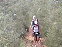 |
Actually there are three with the little dog Rocky, a great name for this trail!
|
|
 |
The Pines Camp is in a small cluster of pine trees in the middle of dry chaparral
|
|
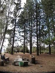 |
It's very pretty and shady here!
|
|
 |
Continuing the climb, the Pines Camp can be seen in the distance, in little above center in the photo
|
|
|
|
|
|
 |
There's an interesting-looking trail on the other side of the canyon, and it looks about as steep as the one we're on
|
|
|


