|
Evening in Supai Village
|
|
 |
The next morning, we spot small barrel cacti growing on the cliffs
|
|
 |
The right side of the New Navajo Falls...
|
|
 |
... More of the New Navajo Falls...
|
|
 |
... Even more of the New Navajo Falls...
|
|
 |
... Left side of the New Navajo Falls...
|
|
 |
... The New Navajo Falls, altogether!
|
|
 |
The water here is very clear. Futher downstream it is an intense milky blue.
|
|
 |
Rock Falls, also created in the flash flood in August 2008
|
|
 |
Swirly patterns of mineral deposits
|
|
 |
Rock Falls
|
|
 |
Rock Falls
|
|
 |
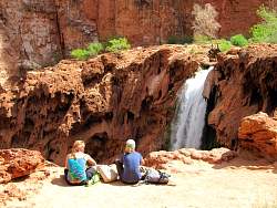
Our first look at Havasu Falls, from the top, 100 feet above the pool below!
|
|
 |
Havasu Falls
|
|
|
|
|
 |
Sign at the campground
|
|
 |
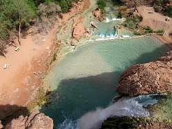
First view of the 200-foot high Mooney Falls
|
|
 |
Trying to look over the top of Mooney Falls. You can't get very close to the edge!
|
|
 |
Mineral deposits to the side of Mooney Falls. The path to the bottom is through these deposits.
|
|
|
|
|
|
 |
Starting down the path to the bottom of Mooney Falls
|
|
 |
Part of the path is through a steep tunnel!
|
|
|
|
|
|
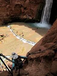 |
Coming out of the tunnel, chains provide handholds. This part can be pretty scary!
|
|
|
 |
Looking at the chains from the bottom. There's a ladder to get you to the very bottom.
|
|
|
|