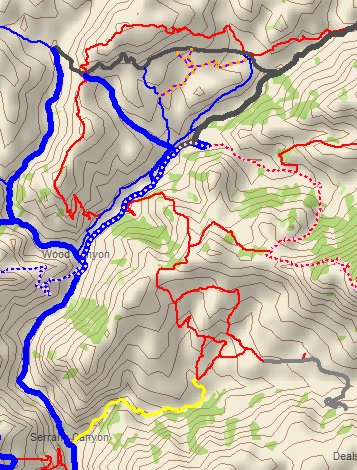
- Heavy lines are fireroads
- Thin lines are singletracks
- Medium-width lines are doubletracks or intermediate width trails
- Blue lines are multiuse and open to bikes, hikers and horses
- Red lines are closed to bikes
- Yellow lines are closed to bikes and horses
- Dark grey lines are paved roads
- Light grey lines, solid or dashed, are underlying features on the topo map and probably don't exist, at least not where shown
- The Backbone Trail is indicated by a light pink dot pattern on top of the trail line
- Trails closed to the public are purple with orange dots
- A dotted brown line represents an unofficial or unsanctioned trail
Only the blue, red, yellow, dotted brown and dark grey lines have been mapped with a GPS and are accurately positioned on the map.