Sedona, Arizona, in September, 2007.

Photos are from Karl, Sig, Don, Peggy and Steve. Click on an image to see it full size.

Photos Home

_MapofSedona2D.jpg
Topo map of the Sedona area. The bright red line is the path of the helicopter tour.
_MapofSedona3D.jpg
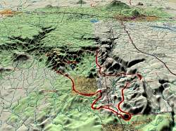
3D representation of the Sedona area. The bright red line is the path of the helicoper tour.

_STA_6808Pan.jpg

View from the vista point on the way up to the airport.

IMG_6746.jpg
In Flagstaff, on the way to Sedona. They don't want you to get lost!
IMG_6753.jpg
Sunset during a thunderstorm in Sedona
IMG_6807.jpg
The Cockscomb, from the Airport vista point
IMG_6807_DSCN1081.jpg
The Sedona Golf Course is actually in the Village of Oak Creek
IMG_6807_DSCN1082.jpg
You want to stay out of the rough on this course!
IMG_6807_DSCN1083.jpg
Quite a spectacular backdrop for golf
IMG_6807_DSCN1084.jpg

IMG_6807_DSCN1091.jpg

P1010060.jpg

P1010062.jpg

P1010064.jpg

P1060619.jpg
Fires in the distance