|
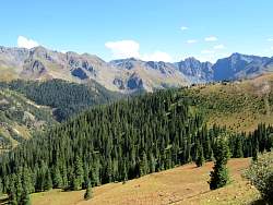
The road down from Hurricane Pass is basically south, and it's pretty steep and rocky.
|
|
|
 |
That road in the distance is where I'm going, to Corkscrew Pass
|
|
 |
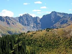
A closer look at Corkscrew Pass Road
|
|
|
|
|
|
 |
That's Gold King Mine, where there was a huge spill of toxic, heavy-metal laced mine water just 5 weeks ago. Milliions of gallons flowed into Cement Creek, through Silverton and Durango, ultimately ending up in the Gulf of California.
|
|
|
|
|
|
|
|
|
|
 |
Past Corkscrew Pass and heading down. The sign was missing at Corkscrew Pass so I don't have a picture there.
|
|
 |
Red Mountain Number 1...
|
|
 |
... Another view of Red Mtn No 1
|
|
|
 |
Looking across Hwy 550 at what could be the back (east) side of Telluride Peak.
|
|
|
|
|
|
|
 |
There were some interesting, and rapidly changing, colors in this cloud.
|
|
|
|
|
 |
Red Mountain Creek carries the rust color of the mountain.
|
|
 |
There's construction on Hwy 550 back to Ouray, with a couple of waits at single-lane sections.
|
|
|
|