Overview
of adjacent areas
|
Trails of
Wood Ranch, Lang
Ranch, Sunset Hills, Woodridge and Oakbrook Regional Park
|
|
|
|
|
| 
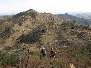
View from Oakbrook
Vista Trail, looking north. Albertson Fire Road is in the foreground
and Lang Ranch is at the left. Wood Ranch is out of view behind
the hills.
|
Overview
This area lies between the Wood Ranch area of Simi
Valley to the north, the Lang Ranch area of Thousand Oaks to the
west, and the Palo Comado / Cheeseboro Canyon area to the south-east. There are
some nice single tracks although it is mostly fire roads, connecting to Palo Comado and Cheeseboro Canyons through China Flat.
There are no shady oak groves as in Cheeseboro, but the jagged
sandstone ridge that includes Simi Cave is beautiful to view from below, and
spectactular to hike through. In the summer this area is stinking hot
and there is little shade. For geocachers, caches
are not allowed in Cheeseboro and Palo Comado, but there are quite a few of
them in this area.
For hikers, the eastern sections of the Sandstone Hills Trail provide
some great views up to the sandstone rocks of the bluff that forms Simi Peak.
The Secret Passage to Simi Cave follows along the edge of this bluff, immersing
you in these rock formations and giving spectacular views of Oak Park down
below. In the spring, the Oakbrook Vista Trail is lined by blooming purple sage.
In the fall of 2016, COSCA embarked on a trail naming project
for this area, giving tentative names to some previously unnamed trails. I assume
those tentative names will be approved, so I have used them on this map.

Trailheads
a. Lang Ranch Parkway, a few hundred yards east of Westlake Blvd.
There is plenty of parking here. Map
and directions
b. The east end of Lang Ranch Parkway. There is
plenty of parking here. Map
and directions
c. Westlake Blvd at Oak Valley Ln. Map
and directions
d. Sunset Hills Blvd. There is plenty of parking
here. Map
and directions
e. Wood Ranch Parkway at Long Canyon Rd. There
is plenty of parking here. Map
and directions
f. Westlake Blvd near Allyson Ct. There is no parking
on Westlake Blvd. Map
and directions
g. The west end of Falling Star Ave. There
is plenty of parking here. Map
and directions
h. Pathfinder Ave. Map
and directions
i. North-west end of Forest Knoll Dr. Map
and directions
j. Rayburn Street, just north of Kanan Rd. Map
and directions
k. Erbes Road, just east of the 23 freeway. There
is plenty of parking here. Map
and directions
Trails
[1]
Albertson Fireroad T1

[1b]
Long Bridge Trail T2

[12]Montgomery Fireroad
T1
Description Except for the 0.75 mile-long
Long Ridge Trail single
track to bypass private property, this is 100% fireroad, and
mostly climbing. This is one way to
get to China
Flat and the Cheeseboro
area. In the summertime this area is very hot and there is no
shade. Take lots of water and brush up on your first aid for victims
of heat exhaustion. The profile below pretty much tells the story:
lots of climbing to get to China Flat. About 2.5 miles from the
trailhead there is a gate on the north side of the road that blocks
a short connector to the Ridgeline Singletrack.
The road connects to the Edison road that is part of the Bell
Canyon Loop. About 5.5 miles from the trailhead it turns
east through a locked gate but continues straight ahead as Montgomery
Fire Road. Less than a mile further on Montgomery Fire Road dead
ends at a locked gate.
Download the GPS track  to help you
find your way.
to help you
find your way.
Technical Rating T1
|
Length (miles)
|
3.0 to China Flat Access. 6.2 to
the locked gate on Montgomery Fire Road |
|
Climb (feet)
|
1700, 1200 to the China Flat connector |
|
Descent (feet)
|
900, 240 to China Flat connector |
Trail Profile Back
to the Top

[2]
Autumn Ridge Trail T1
[3]
Alapay Trail (AKA Lang Ranch Ridge Trail) T1
(AKA Lang Loop
Fire Road)Description With a little piece of Albertson Fire Road, these
two trails form a loop through Lang Ranch. The trailhead for the Autumn Ridge
Trail is at the end of Westlake Blvd where it intersects with Autumn
Ridge Drive. The trail is well maintained. It mostly climbs, in
one spot very steeply, up to the Sunrise Trail. The second part
of the loop, Alapay Trail, continues to climb
to the Rocky Incline Trail. From there it descends remarkably evenly
to the Albertson Fire road. The Albertson trailhead is 0.6 miles
west at the end of Lang Ranch Parkway. To complete the loop, head
west on Lang Ranch Parkway (not up the hill; that way is north)
a couple of blocks to Oak Valley Lane, turn right and continue until
Westlake Blvd comes in from the left.
Download the GPS track
to help you
find your way.
Technical Rating T1
|
Length (miles)
|
Autumn Ridge Trail: 1.3, Alapay
Trail: 1.1, Total: 2.4 |
|
Climb (feet)
|
Autumn Ridge: 500, LAlapay Trail:
120, Total: 620 |
|
Descent (feet)
|
Autumn Ridge: 100, LAlapay Trail:
480, Total: 580 |
Trail Profile Back
to the Top

[4]
Sunrise Trail T2
[5]
Meadow Vista Trail T2.5

Description These trails are
fire roads but most
doesn't seem to get much if any vehicular traffic so would
be better classified as a double-track. In some spots it's barely
wide enough to be called even that. There are three sections to
this road. The first, Sunrise Trail, the first 200 yards of which
encompasses part of Woodbridge Loop and then climbs
up to a ridge where you overlook Wood Ranch to the north and
the Lang Loop trail on the other side. Expect some ruts here and a couple
of
steep and nasty but not very long climbs. Sunrise Trail ends where
it meets Autumn Ridge Trail, and where Meadow Vista Trail and the second
section starts. Until the intersection with Ridgeline Trail, the road
is very well maintained and climbs gently. The last section
is downhill to Albertson Fire Road. It's rocky at first where
it's steepest, but soon becomes pretty smooth. It's all downhill
to Albertson Fire Road except for the last few hundred yards.
Download the GPS track
to help you
find your way.
Technical Rating T2.5
|
Length (miles)
|
Sunrise Trail: 1.4, Meadow Vista Trail:
1.2, Total: 2.3 |
|
Climb (feet)
|
Sunrise Trail: 500, Meadow Vista Trail:
250, Total: 750 |
|
Descent (feet)
|
Sunrise Trail: 300, Meadow Vista Trail:
370, Total: 670 |
Trail Profile Back
to the Top

[6]
Rocky Incline Trail (AKA Hidden Canyon Trail, Rocky Singletrack) T3.5


Mark
took the photos that make up this panorama - Thanks, Mark!
Description This single track starts at the
highest point of the Alapay Trail and descends to Meadow
Vista Trail about 0.4 miles
before it meets Albertson Fire Road. It is very rocky
in many sections and ins not appropriate for inexperienced mountain
bikers.
Download the GPS track
to help you
find your way.
Technical Rating T3.5
|
Length (miles)
|
0.6 |
|
Climb (feet)
|
130 |
|
Descent (feet)
|
320 |
Trail Profile Back
to the Top

 [7]
Ridgeline Singletrack T2.5
[7]
Ridgeline Singletrack T2.5
Description For mountain bikers this is a very fun single track
that starts at the top of Meadow Vista Trail and follows
the crest of a ridge. Some of the climbs are a little steep but
not technical, except for the last descent which ends at an equestian road.
The road is on private property belonging to the Bridle
Path Homeowner's Association. They really really don't like outsiders on
their property, and mountain bikers especially are not welcome. You've been
warned! Even though you can't get out at the east end, an out-and-back ride is
okay because this trail is equally fun to ride in both direction.
Download the GPS track
to help you
find your way.
Technical Rating T2.5
|
Length (miles)
|
1.0 |
|
Climb (feet)
|
280 |
|
Descent (feet)
|
230 |
Trail Profile Back
to the Top

[8]
Long Canyon Trail T3.5
Description This is a single track that starts
at the Sunrise Trail not far north of where the Sunrise Trail meets the Autumn
Ridge Trail and ends
at the parking lot on Long Canyon Rd. Most of it is steep and loose so this is not a good trail
for novice bikers. Recommended direction of travel on a bike: down.
Download the GPS track
to help you
find your way.
Technical Rating T3.5
|
Length (miles)
|
0.9 |
|
Climb (feet)
|
50 |
|
Descent (feet)
|
430 |
Trail Profile Back
to the Top

[9]
Woodridge Connector T2
Description This trail starts very close to
the parking lot at the south end of Wood Ranch Parkway and ends
at west end of the Woodridge Loop. To get to the trailhead,
head from the parking lot to the short paved road that extends Long
Canyon Road west about a block. At the west end go through
the gate, following the fence line of the houses. Shortly you'll
come to a concrete drainage ditch. Be very careful if you ride back
this way - it will be downhill then and the ditch isn't visible
until the last moment! The trail will continue past "Micro
Moab" and skirts some new development before ending at the Woodrige
Loop. This is a pretty easy trail with no strenuous
climbs or technical sections.
Download the GPS track
to help you
find your way.
Technical Rating T2
|
Length (miles)
|
1.2 |
|
Climb (feet)
|
300 |
|
Descent (feet)
|
180 |
Trail Profile Back
to the Top

[10]
Woodridge Loop T2
Description This
short loop of just under 3 miles encircles the gated community at the end of
Sunset Hills Blvd. It is mostly well-travelled and firm singletrack but
includes a little doubletrack/dirt road and even a short stretch on the pavement.
It's perfect for a short hike or run after work.
There is a short spur about 360 yards north-east of the Sunset
Hills Blvd Trailhead. This spur leads west and down to a drainage basin where
a number of BMX stunts have been built.
Download the GPS track
to help you
find your way.
Technical Rating T2
|
Length (miles)
|
2.8 |
|
Climb (feet)
|
650 |
|
Descent (feet)
|
650 |
Trail Profile Back
to the Top

[11]
Sunset Hills Trail T2
 Description This
singletrack connects the north-west corner of the Woodridge Loop to Erbes Road just
east of the 23 Freeway. It is quite well travelled but could be overgrown with
mustard in the spring. The tread is mostly smooth and firm.
Description This
singletrack connects the north-west corner of the Woodridge Loop to Erbes Road just
east of the 23 Freeway. It is quite well travelled but could be overgrown with
mustard in the spring. The tread is mostly smooth and firm.
In October 2011 during the COSCA
Annual Trailwork Day, slightly more than 1 mile was added to the trail by
about 170 volunteers. The new section, in the very top-left corner of the
map, in part follows an old roadbed, but also contains a newly built section
that provides great views of the Wood Ranch (Bard) Reservoir. The new trail
is less steep than the old trail (shown in red on the profile below) so makes
for a fairly easy hike or ride. The old trail still exists and can be used to
make a 1.8 mile loop, starting from the Erbes Road parking area.
From the loop at the north-west end, the trail heads south-east
close to a ridgeline and along a fence for much of it. The fence defines the
boundary between Thousand Oaks and Simi Valley. (It is there to keep us out
of the reservoir watershed, not to keep us out of Simi Valley!) and ends at
the Woodridge Loop Trail. Along the way there are excellent views down into
the neighborhood and the city beyond.
Download the GPS track
to help you
find your way.
Technical Rating T2
|
Length (miles)
|
2.5 to Woodridge Loop |
|
Climb (feet)
|
700 (from Erbes Rd trailhead to Woodbridge Loop) |
|
Descent (feet)
|
350 |
Trail Profile Back
to the Top

[13]
Oakbrook Vista Trail T2.5
Description This
is the main trail to get you into the Oakbrook Open Space. The photo at the
top of this page of Lang and Wood Ranches was taken from this trail. It starts
on Lang Ranch Parkway where there is plenty of parking and climbs quickly to
give you a good view of the Lang Ranch houses and a very good workout at the
same time. The lower sections are lined by purple sage so you will see lots
of color in the spring. About a third of a mile from the trailhead, the trail
joins an old road and opens up a bit. (At this point there is an old trail that
forks downhill to the south. That trail starts out pretty well, but quickly
deteriorates after passing a geocache. Some bushwhacking through the old trail
will get you out to Westlake Blvd near an apartment complex.)
Continuing up the Oakbrook Vista Trail, about 0.9 miles along
and near the top of the climbing, the Oakbrook Water Tank Road leads doward
to the south-west, and eventually to Westlake Blvd. Shortly after passing the
Oakbrook Watertank Rd, this trail forks with the main trail narrowing and veering
left (a rough, loose and steep doubletrack continues up the ridgeline and rejoins
the main trail across from the Secret Passage Trail). At about 1.3 miles from
Lang Ranch Parkway, the trail emerges into a meadow. To the right (north)
and sometimes difficult to see is the Secret Passage to Simi Cave. Forward another
200 yards is an Edison Road (Sandstone Hills Trail) that can take you east along the base of the rocky
bluffs of Simi Peak, or south-west back to the pavement. Continuing east on
the Sandstone Hills Trail will bring you to the very fun (to ride) Hidden Meadows Trail
singletrack.
Download the GPS track
to help you
find your way.
Technical Rating T2.5
|
Length (miles)
|
|
|
Climb (feet)
|
|
|
Descent (feet)
|
|
Trail Profile Back
to the Top

[14]
Sandstone Hills Trail T1
,
T3

[14b]
North Fork Sandstone Hills Trail T1
Description The Sandstone
Peak Trail starts at the west end as a double-track trail that climbs from Rayburn
Street up to an Edison Road. At the Edison Road, take the right fork to head
east and continue on the trail.
Once on the Edison road, you
pass the east end of the Oakbrook Vista Trail and then the top of
the Hidden Meadows Trail.
A half mile east of the Hidden Meadows Trail, the Edison Road forks. The northern
fork dead ends after 0.6 miles, but provides access to the Secret Trail up to
the Secret Passage to Simi Cave. The Sandstone Hills Trail continues on the
southern fork and the Edison road ends after
0.6 miles, but the trail continues as a singletrack on to Forest Knoll Drive or Pathfinder Avenue.
Download the GPS track
to help you
find your way.
Technical Rating T1
(Edison Rd), T3
(Doubletrack and Singletrack sections)
Trail Profile Back
to the Top

[15]
Hidden Meadow Trail T2
Description This
trail is a pleasant hike of a bit less than a mile, or a really fun ride on
a bike! It leads from the end of Falling Star Avenue to Sandstone Hills Trail. It
was rerouted and rebuilt in 2007 during the COSCA
Trailwork
Day from a treacherous steep trail to the great trail it now is. View the
photo gallery
of the rebuilding effort.
Download the GPS track
to help you
find your way.
Technical Rating T2
|
Length (miles)
|
0.8 |
|
Climb (feet)
|
250 (Falling Star Ave to the Sandstone Hills
Trail) |
|
Descent (feet)
|
125 |
Trail Profile Back
to the Top
 [17]
Secret Passage to Simi Cave (AKA Rabbit Ridge) HO
[17]
Secret Passage to Simi Cave (AKA Rabbit Ridge) HO
 T4.5
T4.5 
Description This
is by far the most interesting trail in the region and traverses one of the
prettiest areas in Ventura County. It starts at the Oakbrook Vista Trail 1.3
miles from the trailhead on Lang Ranch Parkway, and ends a bit beyond the Secret Trail. Along the way are some fantastic rock formations
beside the trail and visible in the distance. Of particular note are the formations
0.2 miles from the start off to the north (there's a spur that leads to these
rocks; a great place for a snack after a short hike), the old gate at the
highest point and the small
cave about 0.15 miles beyond that, shortly before the top of Secret Trail. Much of it travels along or
close to the rideline, giving great views north towards Simi Valley and south
overlooking Oak Park. Like the surroundings, the trail is rocky and quite steep
in a number of places. It is too rugged for horses and strong legs will be needed
to carry hikers to the top. The is generally not too hard to follow but there
are some sections where it it ambiguous, especially up the steep section about
0.65 miles from the start, so it is recommended you download the track to your
GPS and use that to help you stay on the correct trail.
Download the GPS track
to help you
find your way.
Technical Rating HO
T4.5
|
Length (miles)
|
1.4 (Heading east from the Oakbrook Vista Trail) |
|
Climb (feet)
|
700 |
|
Descent (feet)
|
180 |
Trail Profile Back
to the Top

 [18]
Secret Trail HO
T5
[18]
Secret Trail HO
T5

Description The
Secret Trail provides the fastest way up to Simi Cave from Oak Park, and an
alternative route back from the Secret Passage to Simi Cave trail. It starts
at the east end of the north fork of the Sandstone Hills Trail and climbs very steeply
to the Secret Passage trail, giving spectacular views of the rock formations
above. From there it is about 0.1 miles to Simi Cave. As noted, the trail
is very steep and also loose in some sections. Some parts are hard to follow,
so it is recommended you load the following track into your GPS and use that
to help you find your way.
Download the GPS track
to help you
find your way.
Technical Rating HO
T5
|
Length (miles)
|
0.2 |
|
Climb (feet)
|
270 (From the Sandstone Hills north
fork to Secret Passage trail) |
|
Descent (feet)
|
35 |
Trail Profile Back
to the Top
[19]
Oakbrook Watertank Road T1
Description This trail starts at Weslake Blvd as an
Edison Road. When travelling east, at the top of the first hill, turn left and
up the doubletrack (the Edison road continues straight down the hill and across
private property). When the doubletrack meets the paved drive to the water tank,
turn right and after a short distance, bear right onto the dirt track. This
dirt road continues past the tank
and then runs
along a ridgeline to join the Oakbrook Vista Trail.
This route is quite a bit less steep than the up the Oakbrook
Vista Trail from the Lang Ranch Parkway trailhead. The downside is that there's
no parking at this trailhead on Westlake Blvd.
Download the GPS track
to help you
find your way.
Technical Rating T1
|
Length (miles)
|
1.0 |
|
Climb (feet)
|
380 (travelling north-east) |
|
Descent (feet)
|
40 |
Back
to the Top

[21]
Bell Canyon Loop Connector (AKA "The Chute")Description This short single track starts with
a short scramble down from Albertson
Fire Road to a lovely, easy and shady ride through the trees.
It joins the Edison road 0.3 miles west of the single track that
is part of the Bell
Canyon Loop.
Download the GPS track
to help you
find your way.
Technical Rating
|
Length (miles)
|
0.3 |
|
Climb (feet)
|
zero (when starting at the Albertson
Fireroad) |
|
Descent (feet)
|
140 |
Back
to the Top
This page last updated on December 15, 2020