![]()
![]()
![]()
![]()
![]()
|
|
|
|
|
|
|
Overview and Map Details for |
|
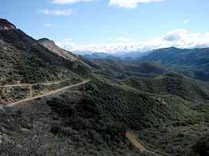
Little Pine Little Pine - Santa Barbara (aka: "Little Grind"). Climbers, this is your ride! Are you ready for 11 miles of relentless fire road ascending that will make Bull Dog look like a speed bump??? Rewarded by approximately 6 miles of very sweet, challenging single track descending down a beautiful canyon landscape that will challenge everything you thought you knew about riding in dirt! The view from the base of "The Wall" Directions: Take the 101 to Santa Barbara, exit "154/Lake Cachuma", and go straight through the signal light (crossing Hollister Ave). This road will curve around to the left and take you to another major signal intersection, turn RIGHT. This is Hwy 154. The 154 is a curvy mtn road that will take you up over the mountain. Once you cross a very long bridge, look for the Paradise Road turn-off, and turn RIGHT. Travel all the way down to the Forest Ranger kiosk (a little shack) in the middle of the road, where you can purchase a Day Pass. Continue straight across the riverbed cement bridge and bear left up the hill to the upper parking lot, at the trailhead to the Santa Cruz trail. Plan on a travel time of an hour and a half from Thousand Oaks in light traffic.
Cruising down the Santa Cruz Trail |
|
|
The view below is from the west, looking due east. In th foreground, the heavy blue line is the Buckhorn fire road up and the lighter blue line is the Santa Cruz Trail down. Click on any trail to get to its description. |
 Description
From the Lower Oso parking lot there is a singletrack that parallels the road to the Upper Oso parking area for about a mile. From there, the fire road climbs for just over 11 miles to the summit. The first 9.5 miles is very well maintained. About 0.7 miles from the upper parking lot, the Santa Cruz Trail comes into the road on the left. This is the way you will be coming back down. The road is steepest from here for about a mile. After that, the climb is much more gradual and pleasant, or at least, less unpleasant. About 3.6 miles from the bottom is the Camuesa Rd Connector Trail on the right. This is a good place to stop and wait for stragglers. Just over 5 miles from the beginning is an intersection with FR 5N15, Camuesa Rd. Stay left on Buckhorn Road towards Little Pine. At about 7 miles the road starts up "The Wall." Although it looks imposing, it really isn't any steeper than the rest of the road. At 10.5 miles there is a cylindical structure on the left side of the road. Take the turnoff here towards Happy Hollow. At 12 miles a single track joins the road on the right, goes around a little fence, then climbs to the top where there is a spectacular view of the Santa Ynez River Valley and coastal mountains. Congratulations, you've made it to the top!
If you think this trail is steep, see how it compares to other steep trails.
|
Length (miles) |
12.4 | |
|
Climb (feet) |
4000 (Aproximate. Because of the steepness of the hillsides, measuring the ascent and descent is not very accurate.) | |
|
Descent (feet) |
800 | |
Trail Profile

Description: This is a super-sweet, somewhat technical single track descent for just over 5 miles before it meets up with the main fire road. This trail has a reputation for being very technical and difficult, but it isn't so bad. It's definitely not for beginners and it has a lot of rocks, but most of it is pretty firm so your tires can get a good grip. The most notable exception (and the most technical part of the trail except for a couple of hike-a-bike washouts) is the first half mile from the top, until you get onto the Santa Cruz trail proper, where it is steep, rocky and rutted. However, the rest of the trail does have a lot of exposure, especially for the first mile, so if you're uncomfortable with a steep dropoff at the very edge of a narrow trail, the fire road might be a better way to get home. For experienced riders, this is one very long and very fun downhill! It is well worth the drive and the long climb to the top.
|
Length (miles) |
5.8 |
|
Climb (feet) |
100 |
|
Descent (feet) |
3300 Back to the Top |
Trail Profile

 [3]
Camuesa Rd Connector Trail
[3]
Camuesa Rd Connector Trail ![]()
Description: This trail starts about 3.6 miles up Buckhorn Rd from the Lower Oso parking area. It is a great, mostly downhill, somewhat technical singletrack that ends on Gibraltar Rd. It's a lot of fun for an experienced rider, but there are a number of sections where poison oak is growing into the trail, so beware.
|
Length (miles) |
|
|
Climb (feet) |
|
|
Descent (feet) |
Back to the Top |
Trail Profile

Description: Refer to the profile below
Trail Profile

Description: This trail has some really fun sections. It also has some sections that go through a dry riverbed with babyheads, gravel and sand. Those parts aren't so much fun, but you should get used to them because they make up about 50% of the trail. Overall there is a little climbing and descent, but not much.
|
Length (miles) |
3.0 long miles |
|
Climb (feet) |
350 |
|
Descent (feet) |
450 Back to the Top |
This page last updated on June 10, 2007
|
|
Thanks for looking at Steve's guide to trails in Ventura County, the Santa Monica Mountains National Recreation Area (SMMNRA) and other locations. |
|


 [5] Babyheads Trail