Trails of
Circle
X Ranch to Encinal Canyon Road
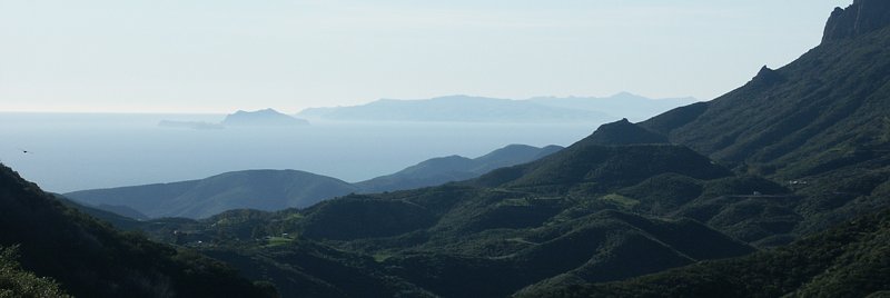
View
of the Channel Islands from the Backbone Trail near Sandstone Peak
|
Trails of Circle
X Ranch to Encinal Canyon Road
|
||
|
||
This is a rugged and somewhat isolated region that spans Los Angeles and Ventura Counties, roughly between Hwy 23 South (Westlake Blvd/Mulholland Hwy) in the east and the Boney Mountain State Wilderness Area in the west.
Circle X Ranch, a former Boy Scouts camp, has some spectacular, otherworldly rock formations. The best way to see them is to hike the Mishe Mokwa Trail to Tripeaks. And in the wintertime after a rainfall, waterfalls abound! One cascades down Echo Cliffs that you can see from the trail to Sandstone Peak (the Mishe Mokwa Trail gets muddy in the wet). The best place to see waterfalls, though, is the Canyon View Trail. There are several large waterfalls that can be seen in this area, and the trail holds up well when wet. If you don't care to dirty your boots, a large waterfall is visible from the parking area at the Sandstone Peak trailhead. Just look west and slightly below Yerba Buena Road.
Even though access to this area is through slow, twisting mountain roads, it's well worth the trip. The views are spectacular on a clear day, especially from trails on the southward-facing slopes where you can see the ocean and Channel Islands to the south. From the Sandstone Peak Trail and Etz Meloy Motorway, you can also see canyons and distant urban areas to the north. Mostly only the Backbone Trail is available for mountain biking, the other trails being too rugged or in the Wilderness Area where bike riding is not allowed. The singletracks between Mulholland and Etz Meloy, and the Yerba Buena segment, are favorites for mountain biking.
At the beginning of June 2016, the Backbone Trail was completed with the addition of a segment that extends the Yerba Buena piece to Etz Meloy Motorway, bypassing the private property at the west end of Ezt Meloy. The east end of Etz Meloy also crosses private property, indicated by the orange/purple segment on the map below.
A short trail leads from Etz Meloy up to a lookout with spectacular views (feature "r" on the map). It's well worth the hike up, but hold on to your hat if it's windy!

There are only a few geocaches in this area, being NPS land as it is.
a. Mishe Mokwa trailhead on Yerba Buena Rd. Map
and directions
b. Sandstone Peak and Canyon View trailheads on
Yerba Buena Rd. Map
and directions
c. Grotto trailhead in Circle X Ranch. Map
and directions
d. Encinal Canyon Road. Map
and directions
e. Arroyo Sequit off of Mulholland Hwy. Map
and directions
f. Clark Ranch Road on Mulholland Hwy. (Map
and directions; There is limited parking here)
g. Canyon View
spur on Yerba Buena Road. Map
and directions
r. Overlook Trail
s. Conejo Peak
t.
The Grotto
u. Balanced Rock and Echo Cliffs
v. Split Rock
w.
Sandstone Peak
x. Inspiration Point
y. Tripeaks
z.
Boney Mountain summit
|
|
Description This segment of the Backbone Trail provides some great views of the ocean to the south and Hidden Valley and beyond to the north. And of course it provides access to Sandstone Peak, the highest point in the Santa Monica Mountains. Combining this with the Mishe Mokwa Trail makes a great loop hike. It is open to biking but it isn't an easy ride. The uphill section from Yerba Buena Rd is very slightly steeper than the upper section of Bulldog but looser and more rutted. Biking is not permitted west of the Mishe Mokwa Trail because the Backbone Trail then enters the Boney Mtn Wilderness Area, which, like all wilderness areas, is closed to mountain bikes. However, this could be combined with the Yerba Buena single track segment of the Backbone Trail, with or without Etz Meloy Mty, to provide an extra challenge.
Download the GPS track
![]() to help you find your way.
to help you find your way.
Technical Rating T3
![]()
|
Length (miles) |
2.6 |
|
Climb (feet) |
1100 (from trailhead on Yerba Buena to Mishe Mokwa Trail) |
|
Descent (feet) |
450 |
Trail Profile Back to the Top

|
|
Description The Mishe Mokwa Trail is a somewhat rugged trail that provides spectacular scenery and diverse terrain. From the trailhead on Yerba Buena Rd, the trail quickly reaches the edge of a canyon with the Echo Cliffs and Balanced Rock on the opposite side. (Echo Cliffs is a favorite spot for rock climbers to practice so you'll often see several suspended on the rock face, part-way up.) In less than a mile the trail drops to the floor of the canyon where it becomes less rugged, but the views of the sandstone formations and rockfalls don't stop. About 1.5 miles in is the Split Rock picnic area, an oak-shaded area that's a good place for a break, long or short. The trail ends when it meets the Sandstone Peak Backbone Trail fireroad, 3.1 miles from the trailhead. Returning on the Sandstone Peak Backbone Trail will provide some great views of the ocean.
The first 0.35 miles, until the Sandstone Peak Connector Trail, is open to mountain bikes and horses, but is open only to hikers beyond there.
Download the GPS track ![]() to help you find your way.
to help you find your way.
The Sandstone Peak Connector Trail (T2
![]() )
is a short trail, less than
1000 feet long, that connects the Sandstone Peak Backbone Trail to the Mishe
Mokwa Trail. It provides a convenient trail to make a loop from the Mishe Mokwa
and Sandstone Peak Trails, regardless of which trailhead you start at. Download
the GPS track
)
is a short trail, less than
1000 feet long, that connects the Sandstone Peak Backbone Trail to the Mishe
Mokwa Trail. It provides a convenient trail to make a loop from the Mishe Mokwa
and Sandstone Peak Trails, regardless of which trailhead you start at. Download
the GPS track ![]() to help you find your way.
to help you find your way.
The Balanced Rock Trail starts at the Split Rock picnic area
on the Mishe Mokwa Trail. It drops slighly and crosses the stream, continuing
up to Balanced Rock and beyond. It ends at an overlook with a great view into
Carlisle Canyon to the east, and of Sandstone Peak and the Mishe Mokwa Trail
to the south. This trail is not maintained and lightly
used, so it can be somewhat overgrown in sections and
difficult to follow. Nevertheless, it is well worth the effort! Download the
GPS track ![]() to help you find your way.
to help you find your way.
|
Trail |
Mishe Mokwa |
Sandstone Peak Connector |
Balanced Rock Trail |
|
Length (miles) |
3.1 |
900 feet |
0.35 (to Balanced Rock) |
|
Climb (feet) |
1000 (from trailhead on Yerba Buena to Backbone Trail) |
50 |
80 (to Balanced Rock) |
|
Descent (feet) |
400 |
50 |
100 (to Balanced Rock) |
Trail Profile Back to the Top

[3,4]
Backbone Trail, Yerba Buena Rd segment T2
![]() and Yellow Hill Fireroad T3.5
and Yellow Hill Fireroad T3.5
![]()
|
|
Description This is a fairly gentle trail, built to modern multi-use standards, meaning it's not too steep, reasonably smooth, about 4-feet wide and perfect for novice riders or for an easy hike. The views are pleasant, but not as good as you get from higher up, for example Etz Meloy Mty, the Sandstone Peak Backbone Trail or Yellow Hill Fire Rd. Nevertheless it's a lot of fun and much less crowded than similar trails in the Santa Monica Mountains. Strong riders and hikers should climb the Yellow Hill Fire Rd spur for much better views of the area.
In early June of 2016, this trail was extended across Yerba Buena Rd and up to Etz Meloy Motorway, an addition of about 1/2 miles. Before this was built, legal access to Yerba Buena Road across the west end of Etz Meloy was blocked by gates and private property.
There is no parking near the east end of this trail where it crosses Yerba Buena, although there is a small space for a couple of cars at the side of the road about a quarter mile west. Since the trail was extended to Etz Meloy, the location where it crosses the road is easy to see. On the other hand, there is lots of parking at the western end, across the street from the Mishe Mokwa trailhead.
The Yellow Hill Fireroad is 0.68 miles long and has 350 feet of elevation gain. Some sections are covered with loose rocks so it can be a bit of a technical challenge to ride, particularly on the way down. There are some great views from the top, however, that make the climb worthwhile.
Download the GPS track
![]() to help you find your way.
to help you find your way.
Technical Rating T2
![]() (Backbone Trail); T3.5
(Backbone Trail); T3.5
![]() (Yellow Hill Fireroad)
(Yellow Hill Fireroad)
|
Length (miles) |
5.0 (4.5 from Yerba Buena to the Mishe Mokwa Trailhead) |
|
Climb (feet) |
550 (500) |
|
Descent (feet) |
700 (500) |
Trail Profile Back to the Top

|
|
Description This fireroad provides some spectacular views in all directions, southward to the ocean, and into Hidden Valley, Thousand Oaks and beyond to the north. The eastern- and western-most sections (dashed line in the elevation profile below) traverse private property and the owners would appreciate it if the public stayed off those parts. One of the newest segments of the Backbone Trail, a singletrack opened in 2007, is one of the favorite trails for mountain bikers, especially combined with the section across Mulholland Hwy that leads to Encinal Cyn Rd and parking. West of the Backbone singletrack, Etz Meloy follows the ridgeline, accounting for the great views to both the north and south. A short singletrack trail, shown in red on the profile below, leads to an overlook with a spectacular view in all directions.
In early June 2016, the National Park Service eliminated one of the two remaining gaps in the Backbone Trail by extending the Yerba Buena segment across the road and up to Etz Meloy.
Download the GPS
track ![]() to
help you find your way.
to
help you find your way.
Technical Rating T2.5
![]()
|
Length (miles) |
1.5 (from Backbone singletrack toYerba Buena Rd) |
|
Climb (feet) |
300 |
|
Descent (feet) |
420 |
Trail Profile Back to the Top

[6]
Backbone Trail, Mulholland to Etz Meloy T2
![]()
[7]
Backbone Trail, Encinal to Mulholland T2
![]()
|
The Backbone Trail singletrack |
Description These two singletrack sections are the latest additions to the Backbone Trail until 2016. The upper section, Mulholland Hwy to Etz Meloy Motorway, was opened in late 2007. The lower section, Encinal Canyon Road to Mulholland Hwy, opened in 2001. As can be seen from the elevation profile below, they both have gentle, consistent slopes that make these trails easy for beginner mountain bikers. They are built to multiuse standard and have a broad, smooth, firm tread. The crew of a nearby fire station keeps the lower section in perfect shape. The lower section is one of the best places to see wildflowers in the spring.
The aforementioned fire crew practices their skills on trails they have built in the area. The National Park Service, the local land manager, requests that the public stays on the Backbone Trail and off of these other trail.
The Backbone Trail continues south and then east on the south side for Encinal Canyon Road, across from the bottom of the lower section described here. The trail descriptions and maps are on the Zuma-Kanan Backbone Area of this web site.
Download the GPS track ![]() to help you find your way.
to help you find your way.
Technical Rating T2
![]()
|
Trail Segment |
Encinal to Mulholland |
Mulholland to Etz Meloy |
Total |
|
Length (miles) |
1.1 |
2.5 |
3.6 |
|
Climb (feet) |
230 |
620 |
850 |
|
Descent (feet) |
30 |
30 |
60 |
Trail Profile Back to the Top

[8]
Clark Ranch Fireroad T1
![]()
Description The Clark Ranch
Fire Road connects Mulholland Hwy to Encinal Canyon Rd. It used
to form part of the Backbone Trail, but sometime in 2004, a new singletrack
section of the Backbone Trail [7] was built that starts and ends
in the same place, but is better in every way. Nevertheless, Clark
Ranch Fireroad can be used to make a loop route with the newer
singletrack. Download the GPS track
![]() to
help you find your way.
to
help you find your way.
Technical Rating T1
![]()
|
Length (miles) |
0.7 |
|
Climb (feet) |
270 |
|
Descent (feet) |
zero |
|
|
Description This well-used trail winds down from the Sandstone Peak Trailhead, but on the downhill side of Yerba Buena Road, to the Grotto Trail. There is a spur a little less than 0.9 miles along that leads back to another parking area on Yerba Buena Road. As the name of the trail suggests, it provides a great view into the valley and canyon that narrows to the grotto for the whole length. The trail surface is somewhat uneven in many places and there are some stream crossings, one of which is a real challenge to cross if there has been a lot of recent rain.
This is probably the best trail for viewing waterfalls during or shortly after significant rainfalls. The trail surface holds up quite well when it is wet and does not turn into sticky mud as the Mishe Mokwa Trail does in some sections. There are several large and many smaller waterfalls that can be seen from this trail. If there is low cloud so the trail is covered in fog, you may be able to hear many waterfalls even when you can't see them. Take a look at the photo gallery for pictures of the waterfalls that you could see.
This trail joins the Grotto Trail near its top. Continuing down the Grotto Trail is a great way to extend an already good hike.
Download the GPS track
![]() to
help you find your way.
to
help you find your way.
|
Length (miles) |
1.5 |
|
Climb (feet) |
60 (Sandstone Peak trailhead and parking to the Grotto Trail) |
|
Descent (feet) |
590 |
Trail Profile Back to the Top

|
|
Description This very popular trail starts in the lower parking area of Circle X Ranch, next to a picnic area with plumbed facilities, and ends a little over a mile later at the grotto, a huge pile of boulders where the valley becomes a narrow canyon and a stream, the West Fork of the Arroyo Sequit, tumbles down ten, 20 or more feet at a time in a series of steps. A few yards beyond where the Canyon View Trail ends is a stream crossing at the top of a 50-foot waterfall. The trail winds around to where you get a great view of this falls and the pool below. If there is a significant amount of water in this stream, do not try to cross it! If you lose your footing, you will almost certainly be swept over the falls to your death on the rocks 5 storeys below!
The formal trail ends at the top of the grotto, but if you like adventure and climbing over and down huge boulders, a path along the west face of the canyon will show you the way down. Be careful, though, because the drops are significant, even dry boulders can be slippery, and you want to make sure you can pull yourself back up! Don't expect to have any cell phone signal here for calling for help. Dogs are not allowed in this part of the grotto.
After a rain, you can see many waterfalls, both near to and far from the trail. However, the West Fork of the Arroyo Sequit that leads to the grotto swells to transport a huge volume of water. This makes for spectacular waterfalls, but also makes crossing it extremely dangerous. Do not attempt this trail if there is much water in the stream! And if it starts to rain after you have crossed the stream, head back up the trail as quickly as you can or you might be trapped by the rising stream. There is only one way out, so be careful! It's best to wait a day or two after a heavy rain before hiking down to the grotto.
Download the GPS track
![]() to
help you find your way.
to
help you find your way.
|
Length (miles) |
1.2 |
|
Climb (feet) |
150 (Circle X Ranch trailhead to the grotto) |
|
Descent (feet) |
500 |

Looking
south, west and northwest from Conejo Peak
Conejo Peak (not to be confused with Conejo Mountain just north of Dos Vientos) sits between Hidden Valley to the north and Carlisle Canyon and Sandstone Peak to the south, just east of Boney Mountain. The views from Conejo Peak are specacular - Hidden Valley to the north, Westlake to the east, Sandstone Peak to the south and Tripeaks and Boney Mountain Summit to the west. There are two routes to Conejo Peak and they are described in the following sections: from Hidden Valley Overlook Trail to the north and from the Mishe Mokwa trail to the south.
[18]
Staber Access Trail T2.5
![]() HO
HO
![]()
Description There are at least three trails connected together to give access to Staber Road from the Hidden Valley Overlook Trail. You will find your way much more easily if you download and follow the GPS track provided below. From the Hidden Valley Overlook Trail, take the south fork at the east end of the meadow. This is the beginning of Staber Access Trail. It starts off quite broad and narrows a bit as you descend. The trail passes through a broken gate and then joins what may be a private equestrian trail. The trail goes uphill and continues up the ridgeline just before the point where the equestrian trail turns and heads downhill. The trail from here isn't as frequently used and is quite narrow. It passes by a mountain lion capture area (be sure not to disturb the traps!) then steepens before it emerges at Staber Road.
Download the GPS track
![]() to
help you find your way.
to
help you find your way.
|
Length (miles) |
0.7 |
|
Climb (feet) |
420 |
|
Descent (feet) |
230 |
Trail Profile Back to the Top

[19]
Staber Road T2
![]()
Description This fireroad climbs from Hidden Valley to Conejo Peak. The lower portion of the road is inaccessible because it goes through private property, but it can be reached from the Hidden Valley Overlook Trail by way of an access trail. It climbs quite steeply but is broad and well travelled. Near the top, surprisingly, it passes through a grove of oak trees. At the top it forks to head generally east and west. The top section is less than a half mile long with 100 feet or less of climbing and descent from one end to the other.
Download the GPS track
![]() to
help you find your way.
to
help you find your way.
Technical Rating T2
![]()
|
Length (miles) |
1.3 (from access trail to junction at the top) |
|
Climb (feet) |
1100 |
|
Descent (feet) |
zero |
[20]
Mountaineer's Loop to Conejo Peak T3
![]() HO
HO
![]()
Description The Mountaineer's Loop provides access to Conejo Peak from the Balanced Rock trail to the south. The west leg starts about a tenth of a mile east of Split Rock and heads steeply up the hill. In many places it is very narrow. At one point it crosses a meadow - it may take some searching without the GPS track to find the point where it continues near the top of the meadow. The path continues almost straight up the hill. At the rock faces, the trail climbs through a couple of crevices. They are both several feet high and have many places for grip so they are pretty easy to climb. At the top, the loop continues on Staber Road for about a tenth of a mile, then forks off to the right and slightly downhill. The east leg is also narrow but isn't as steep as the west fork. It comes out near the east end of the Balanced Rock Trail which returns to the start.
Download the GPS track
![]() to
help you find your way. Note: This track isn't very accurate close to
the rock faces when climbing up on the west leg of the loop.
to
help you find your way. Note: This track isn't very accurate close to
the rock faces when climbing up on the west leg of the loop.
|
Length (miles) |
1.6 (from the Mishe Mokwa Trail at Split rock and back, including the Balanced Rock Trail) |
|
Climb (feet) |
650 |
|
Descent (feet) |
650 |
Trail Profile Back to the Top

Yerba Buena Road, Little Sycamore Canyon Road,
and Mullholland Hwy T0
![]()
Description Many of the trails in this area cross the pavement. We can take advantage of this to arrange shuttle hikes, or to ride back on the road when too pooped return on the trails. The profile below shows where the trails meet the road relative to the distance on the pavement, starting at Circle X Ranch and heading east to Clark Ranch Road. Note that the name of Yerba Buena changes to Little Sycamore Canyon Rd at the Los Angeles County line.

This page was last updated November 16, 2021
|
|
Thanks for looking at Steve's guide to trails in Ventura County, the Santa Monica Mountains National Recreation Area (SMMNRA) and other locations. |
|


