Trails of
Malibu Creek State Park, Agoura Hills
and surrounding area

View of
Century Lake from the Lookout Trail, above Crags Road.
|
Trails of Malibu Creek State Park, Agoura Hills
and surrounding area
|
||
|
|
||
Malibu Creek State Park and the connecting trails have something for everyone. There are novice trails here, as well as one of the most demanding. The trails in the park proper are generally quite easy because they wind through the valleys and don't have a lot of climbing, but neither are they dead flat and boring. Since they have mountains on at least one side at all times, the scenery is always more than pleasant and frequently spectactular. And from the park you can get to the Backbone Trail, the holy grail of trails in the Santa Monica Mountains. Connecting them is the imfamous Bulldog Motorway - you either love it or hate it - as it climbs 1750 feet from the valley floor to the Castro Motorway on Castro Ridge.
This area has a rich history of providing backdrops to distant places for Hollywood, from silent films to the most well-known use, the filming of the movie and TV series M*A*S*H in the 1970's. Many other shows were made here as well.
The trails of Malibu Creek State Park connect to many of the trails in Calabasas through the Las Virgenes View Trail which starts a few hundred yards from where Grasslands Trail crosses Mulholland Hwy.
Deciding which trails to include in this section of the trails guide was somewhat arbitrary as the Backbone Trail continues westward from what is shown here to Kanan Road, Zuma Ridge, Decker Road (23 South) and beyond. In the end, the split was made based partly on what trails connect to make good rides (although at the cost of breaking up the Backbone from Kanan ride onto two maps) and partly based on logistic concerns of having more condensed maps that take up less space on the web pages and therefore take less time to load.
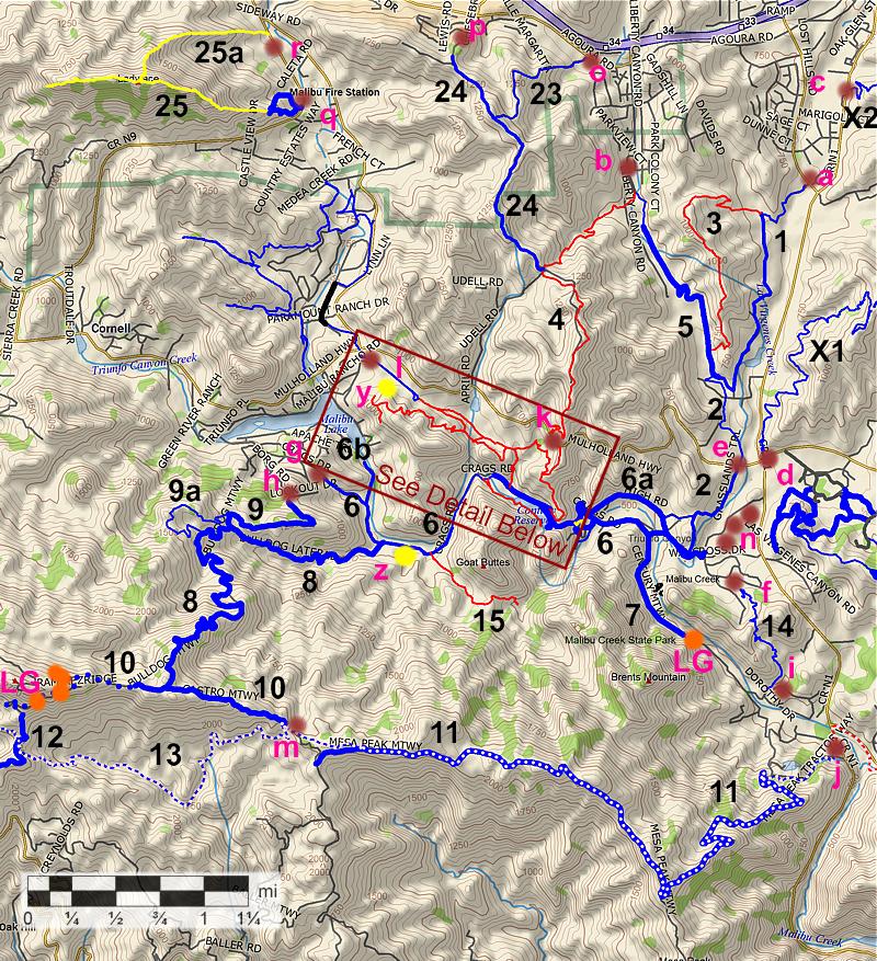
Detail of hiking trails in Malibu Creek State Park

a. Grasslands trailhead and parking at De Anza Park on Lost Hills Rd
about 1 mile south of the 101 freeway,
just north of Las Virgenes Rd (Map
and Directions)
b. The south end of Liberty Canyon Rd, less
than a mile from the 101 freeway. (Map
and Directions)
c. Bark
Park trailhead and parking on Las Virgenes Rd, about 1 mile south of the 101
freeway (Map
and Directions)
d. Las Virgenes View Trail Trailhead and parking on the north-east
corner of Las Virgenes Rd and Mulholland (Map
and Directions)
e. Grasslands trailhead
and parking on Mulholland, 300 yards west of Las Virgenes Rd (Map
and Directions)
f.
Tapia Spur trailhead in Malibu Creek State Park
g. Crags Rd trailhead
at the east end of Crags Drive. There is no parking here (Map
and Directions)
h. The top of Lookout Drive (no parking) (Map
and Directions)
i. Tapia Park on the west side of Malibu Canyon Rd, about 1.5 miles south of
Mulholland Hwy. Fee to park (Map
and Directions)
j. Picnic area on the west side of Malibu Canyon
Rd, about 1.8 miles south of Mulholland Hwy. Fee to park (Map
and Directions)
k. Phantom and Cistern
trailheads on Mulholland Hwy, about 1.8 miles west of Las Virgenes Rd, at the
highest point on the way to Cornell Rd. (Map
and Directions)
l. Parking area on the
access road to Reagan Ranch and a state park facility. The access road is about 200 ft south
of the intersection of Mulholland and Cornell Rd (on Lake Vista Dr). Turn into
the access road and you'll see the parking area on the left. There's a dirt
track that runs parallel to the access road that leads to Deer Leg Trail (east) and across the street
to Paramount Ranch (west). (Map
and Directions)
m.
- Corral Canyon parking lot at the north end of Corral Canyon Road. (Map
and Directions)
n. - Parking in Malibu Creek State Park.
There is a fee to park here. The entrance to the park is about 850 ft south
of Mulholland Hwy on Las Virgenes Rd, on the west side. You can avoid the fee
if you park at d or e instead. (Map
and Directions)
o. Parking at the base of Heartbreak
Hill on Agoura Rd, west of Liberty Canyon Rd. (Map
and Directions)
p. Parking on Agoura
Rd at Lewis Rd (Map
and Directions)
q. Parking on Kanan Rd at the base of the Ladyface
Trail, just north of Silver Creek Rd (Map
and Directions)
r. Parking at the west side of Kanan Road, about
400' south of Cornell Rd (Map
and Directions)
| [1]
Las Virgenes Fireroad, Las Virgenes Trail (AKA
Grasslands Trail) T2.5
[2] North Grasslands Trail, Grasslands Trail T2.5 |
|
The
Grasslands trails are very easy, gently rolling
and hardpacked dirt trails that are suitable for beginning riders.
There two very short steeper sections, the first about a mile from
De Anza Park and the second just before the trail runs into Crags
Road. From De Anza Park, a single-track heads south, crosses a short
bridge, then joins a fire road that roughly parallels Las Virgenes
Road. About a mile and a half from the start another road comes
in from the right. You can go either way, straight and near some
buildings or right and up the little hill because they come together
again after a few hundred yards. Download the GPS track
Technical Rating T2.5
|
|
Length (miles) |
3.1 |
|
Climb (feet) |
340 |
|
Descent (feet) |
520 |
Trail Profile Back to the Top

[3] Talepop Trail: (aka Talopop) NB
![]()
|
Description The Telepop Trail branches off from Grasslands just beyond the first bridge, closest to De Anza Park. It climbs up a ridge, follows it south for a ways, then drops down into Liberty Canyon. The first few hundred yards (from the Grasslands side) are through an open area. The trail surface is hard packed but a little uneven because of holes that have hardened in the dirt. Next the trail enters the mouth of a small canyon, then switchbacks and climbs north and back eastward. The trail seems to have a lot of traffic and so is quite broad, and has a moderate climb. Just before reaching the ridgeline there is a small grove of oak trees. Continuing along the ridgeline, southeasternly, the trail becomes slightly overgrown with some branches hanging into the middle of the trail. During tick season, you'll want to stop frequently and check for hitchikers. From the ridge there are great views to the west into Liberty Canyon and to the east into Las Virgenes Canyon and beyond. You can even see the Calabasas Trails and the Pyramid Switchbacks in the far distance. Continuing southward, the trail mostly follows the ridgeline, then descends fairly steeply into a large meadow before ending at the Liberty Canyon Trail. Overall this is a fairly easy trail to hike but there is little shade.
Download the GPS track
![]() to help you find your way.
to help you find your way.
Technical Rating NB
![]()
|
Length (miles) |
1.8 |
|
Climb (feet) |
400 (starting at Grasslands Trail) |
|
Descent (feet) |
450 |
Trail Profile Back to the Top

[4]
Phantom Trail NB
![]()
 The Phantom Trail starts at the south end of Liberty Canyon Rd and ends at
Mulholland Drive. The Liberty Canyon trail bears left from the end of
the pavement, but the Phantom Trail goes straight then right. After a few hundred
yards the trail reaches a gravel road. The trailhead proper is across the
road and a few yards down. The first quarter mile is quite flat and goes through
some near-wetlands with stands of giant grass. The next 3/4 mile follows
along the bottom of a canyon where the ground it very wet with luxuriant plant
growth. In many places the vegetation forms a tunnel over the trail. In this wet area poison oak
encroaches on the trail in several places. This section will take some time
to dry out after rain, being shaded by trees and on the north slope. The trail
next climbs out of the canyon and mostly follows a ridgeline firebreak, except
it vears away from the peaks to avoid the two steepest climbs. From the ridge
there are many places with spectacular views in all directions. There are a
few intersecting fireroads but the trail is well marked and easy to follow.
Most of the trail is exceptionally quiet with no traffic noise until you
get into view of Mulholland Hwy. It drops down some switchbacks to Mulholland
where it ends. A few hundred yards up Mulholland and on the other side, the
Cistern Trail begins. Overall the trail is moderate in difficulty, well maintained and has
good signage.
The Phantom Trail starts at the south end of Liberty Canyon Rd and ends at
Mulholland Drive. The Liberty Canyon trail bears left from the end of
the pavement, but the Phantom Trail goes straight then right. After a few hundred
yards the trail reaches a gravel road. The trailhead proper is across the
road and a few yards down. The first quarter mile is quite flat and goes through
some near-wetlands with stands of giant grass. The next 3/4 mile follows
along the bottom of a canyon where the ground it very wet with luxuriant plant
growth. In many places the vegetation forms a tunnel over the trail. In this wet area poison oak
encroaches on the trail in several places. This section will take some time
to dry out after rain, being shaded by trees and on the north slope. The trail
next climbs out of the canyon and mostly follows a ridgeline firebreak, except
it vears away from the peaks to avoid the two steepest climbs. From the ridge
there are many places with spectacular views in all directions. There are a
few intersecting fireroads but the trail is well marked and easy to follow.
Most of the trail is exceptionally quiet with no traffic noise until you
get into view of Mulholland Hwy. It drops down some switchbacks to Mulholland
where it ends. A few hundred yards up Mulholland and on the other side, the
Cistern Trail begins. Overall the trail is moderate in difficulty, well maintained and has
good signage.
Download the GPS track
![]() to help you find your way.
to help you find your way.
Technical Rating NB
![]()
|
Length (miles) |
2.5 from Liberty Canyon Rd to Muholland |
|
Climb (feet) |
800 |
|
Descent (feet) |
540 |
Trail Profile Back to the Top

| [5]
Liberty Canyon Trail T1.5
|
|
Description The Liberty Canyon Trail is an alternate route to get to the park, starting at the south end of Liberty Canyon Road. There's not much parking there, so it's not a good place to start for a big group. The trail starts off paved for a few hundred yards, has a short section of single track, and then joins a fire road. There is another section of single track to go around some private property, but soon it's back to the fire road and then the junction with Las Virgenes Trail and Grasslands. This is an easy trail that is good for beginners. Download the GPS track
Technical Rating T1.5
|
|
Length (miles) |
1.1 |
|
Climb (feet) |
180 |
|
Descent (feet) |
100 |
Trail Profile Back to the Top

| [6,
6a, 6b]
Crags Road, High Road and Malibou Lake Dam Spur
T1
|
|
There is a rich history of this area for Hollywood. Download the GPS track
Technical Rating Mostly
T1
|
|
Length (miles) |
3.3 |
|
Climb (feet) |
580 |
|
Descent (feet) |
320 |
Trail Profile Back to the Top

[7]
Mott Road (AKA Century Motorway) T1
|
|
Description Mott Road (so called on the Park map, but called Century Motorway on other maps) is a lovely dirt road that runs along the bottom of a steep valley for about a mile, where there is an impassable gate where the park meets private property. This is a perfect, short and very pretty out and back trail for beginner mountain bikers or family hikes with young children. Download the GPS track
Technical Rating T1
|
|
Length (miles) |
1.1 |
|
Climb (feet) |
130 |
|
Descent (feet) |
170 |
Trail Profile Back to the Top

| [8,
9, 9a]
Bulldog Motorway, Lookout Road and Lakeside Lateral T2
|
|
Description The profile of Bulldog below tells most of the story of this fire road - it's a steep, long grind. Most of it is in good shape, especially the lower half, but there are some rutted and rocky sections further up. This trail is not for the faint of heart! For those who want a taste of Bulldog but might not be up to the whole climb, they can do what we call Little Bulldog Loop. Starting from Crags Rd about a quarter mile west of the M*A*S*H site, you turn left onto Bulldog and climb just over a mile until you reach a major fork. You can continue straight ahead on Upper Bulldog or turn about 90 degrees to the right onto Lookout Road which goes up a short hill and then turns right again at the top. The road descends a bit then climbs some more before starting down, then turns left and gets quite steep just before the trailhead at Lookout Drive. This last section can be very loose and rocky. Once on the pavement, you can take either fork of the road (the right fork is steeper and quicker). There is a very very sharp right turn at the bottom of the hill onto Crags Drive, then about a block to the trailhead at the west end of Crags Rd and back into the park. Another alternative instead of climbing all the way to the top of Bulldog is to continue about 1/4 mile past the Bulldog/Lookout fork and take a single track off to the right, Lakeside Lateral. This is a very pleasant single track but may become overgrown and sometimes with poison oak, but it will shortly come to a spot where there used to be an abandoned and much vandalized stone house. You can continue down an old fire road that will run into Lookout Road. If you turn right down the hill to get to get back to Bulldog, or go straight to get to the Lookout Drive trailhead. If you decide to ride all the way to the top of Bulldog, there aren't many options any more. The most popular in the past, to make a loop with the Backbone Single Track, is now blocked by a locked gate on Newton Motorway. You can also make a much longer ride out to Mesa Peak Motorway and get back to the park by the Tapia Spur Trail. If you think this trail is steep, see how it compares to other steep trails. Download the GPS track
Technical Rating Mostly T2
|
|
Length (miles) |
3.6 (Lower and Upper Bulldog); 0.8 (Lookout Road) |
|
Climb (feet) |
2200 (Lower and Upper Bulldog); 150 (Lookout Road) |
|
Descent (feet) |
450 (Lower and Upper Bulldog); 280 (Lookout Road) |
Is Bulldog the toughest trail to climb? Check the comparison of hills and decide for yourself!
Trail Profile Back to the Top

| [10]
Castro Motorway T1.5
|
|
Description The Castro Motorway is a fire road that climbs from the Corral Canyon Rd parking area past the top of Bulldog to the intersection with Newton Motorway and beyond. However, there is no point in travelling west past the top of Bulldog because the road is impassable due to gates where it crosses onto private property. The landowner has a dispute with the park service and does not want the public crossing his land. Download the GPS track
Technical Rating T1.5
|
|
Length (miles) |
0.8 miles (from Corral Canyon Rd to the top of Bulldog) |
|
Climb (feet) |
470 (starting at the Correl Canyon parking area) |
|
Descent (feet) |
30 |
Trail Profile Back to the Top
| [11]
Mesa Peak Motorway and Singletrack (Backbone Trail) T1.5
|
|
Description The Mesa Peak trail is a fire road for most of it's length, but there is a sweet singletrack that gets you down the last half mile. From the Corral Canyon Rd parking area, head down Corral Canyon Rd for a few hundred yards. Mesa Peak Motorway comes in from the left. There will be some more climbs, but nothing too bad, at least not compared to Bulldog. About 2.5 miles from Corral Canyon Rd, a landslide destroyed the original road in the early 2000's, only a few hundred feet before Puerco Motorway forks off. A new road was built around the landslide in 2004, but the map on this page, and the GPS track below, show the route of a temporary bypass. Puerco Motorway forks off to the right and Mesa Peak Motorway goes left. From here it's about a mile and 3/4 downhill before you get to the singletrack that takes you through a picnic area just before you reach Malibu Canyon Rd. A short ride north on the pavement and across a bridge is necessary to reach Tapia Park as the creek flows with quite a volume all year long. From here the Tapia Spur Trail will get you back to Malibu Creek State Park. Download the GPS track
|
|
Length (miles) |
5.3 |
|
Climb (feet) |
930 (starting at the Correl Canyon parking area) |
|
Descent (feet) |
2440 |
| [12]
Newton Motorway T2
|
|
Download the GPS track
Technical Rating T2
|
|
Length (miles) |
0.7 (Latigo Cyn Rd to the Backbone Trail singletrack at the Saddle) |
|
Climb (feet) |
320 |
|
Descent (feet) |
130 |
Trail Profile Back to the Top

| [13]
Backbone Trail Singletrack (more
photos) T3
|
|
Overall, this trail is appropriate for intermediate riders or strong novices. However, to get to the Saddle takes a lot of work, beyond what a novice or even an intermdiate rider could manage. There are, however, a couple of shortcuts. First, you can drive up Corral Canyon Rd from the Pacific Coast Highway, but this is neither a short nor quick drive so isn't very practical unless you happen to live nearby. Another alternative is to ride to the Saddle along the Newton Motorway from Latigo Canyon Rd, a distance of 0.75 miles with about 280 feet of climbing. Download the GPS track
Technical Rating T3
|
|
Length (miles) |
2.6 (From the Saddle to the Corral Canyon Rd parking area) |
|
Climb (feet) |
590 |
|
Descent (feet) |
870 |
Trail Profile Back to the Top

| [14]
Tapia Spur Trail T2
|
|
Download the GPS track
Technical Rating T2
|
|
Length (miles) |
1.5 (not including pavement) |
|
Climb (feet) |
470 (from Tapia to Malibu Creek State Park, the opposite direction as shown on the profile) |
|
Descent (feet) |
390 |
Trail Profile Back to the Top

|
[15] Lost Cabin Trail NB
![]()
Description This trail probably has the most beautiful surroundings in the park with the red sandstone Goat Buttes to the north and green, rugged mountains to the south. It is very secluded with few travellers; even so, it's in fairly good shape and easy to hike. The trail starts at Crags Road just east of the M*A*S*H site as Crags Road turns north into the Creek of Doom. Lost Cabin Trail climbs slowly, reaches a crest and starts downhill. It used to be eroded and overgrown on the downhill side, but sometime in the summer of 2008 some work was done to clear up the trail. It's now a nice easy walk down to the lost cabin site.
Download the GPS track
![]() to help you find your way.
to help you find your way.
Technical Rating NB
![]()
|
Length (miles) |
0.75 |
|
Climb (feet) |
200 |
|
Descent (feet) |
150 |
Trail Profile Back to the Top

 [16] Forest Trail NB
![]()
Description This is another very pretty and very easy trail to hike. Most of it is close to the southern shore of Century Lake and is shaded by large trees, including a grove of redwood trees. It ends at the Century Lake dam. The trail is well-travelled, wide and well-maintained, a good thing because the cool and damp conditions are prefect for poison oak, which grows in most spots along the edge of the trail. It's easy to avoid the poison oak if you stick to the centerof the trail.This is a perfect trail for a hike on a hot summer day.
Download the GPS track
![]() to help you find your way.
to help you find your way.
Technical Rating NB
![]()
|
Length (miles) |
0.5 |
|
Climb (feet) |
almost none |
|
Descent (feet) |
almost none |
Trail Profile Back to the Top
|
|
[17] Cistern Trail NB
![]()
Description: This trail starts few hundred yards up Mulholland from the south end of the Phantom Trail, on the other side of the highway. It leads to the Lookout Trail that forms a loop with Crags Rd in the park. Along the way are some terrific views down onto Century Lake and the mountains behind it. It is in good shape with moderate climbs. There is enough parking by the side of Mulholland Hwy that this provides a good alternative way into the park, but the steepness of this trail and the Lookout Trail to which it connects means it won't be easy for less-experienced hikers.
Download the GPS track
![]() to help you find your way.
to help you find your way.
Technical Rating NB
![]()
|
Length (miles) |
0.24 |
|
Climb (feet) |
30 (travelling south from Mulholland) |
|
Descent (feet) |
100 |
Trail Profile Back to the Top
[18] Lookout Trail NB
![]()
Description This is a well maintained trail with a fairly smooth tread. It connects the Cistern Trail to Crags Road and has some pretty spectacular views along the way. The slope of the eastern half is a little steeper than moderate, but this provides some tremendous views of Century Lake and the surrounding mountains. The western half is not quite so steep and half the trail is in shade of tall chaparral. Overall there are few people on this trail compared to Crags Road, but there are more equestrians.
Download the GPS track
![]() to help you find your way.
to help you find your way.
Technical Rating NB
![]()
|
Length (miles) |
West segment: 0.43; East segment: 0.46 |
|
Climb (feet) |
West segment: 90; East segment: 30 (Starting at the south end of the Cistern Trail) |
|
Descent (feet) |
West segment: 180; East segment: 240 |
Trail Profile Back to the Top
The trail profile is included with that for the Cistern Trail.
[19]
Cage Creek Trail: NB
![]()
Description At it's north end, this trail connects to the west end of the Lookout Trail and the east end of the Yearling Trail. The south end of this trail connects to Crags Road. The trail is mostly shaded and in good shape, a little rougher and steeper than the Lookout Trail. Like the Lookout Trail, there are very few people on it compared to Crags Road.
Download the GPS track
![]() to help you find your way.
to help you find your way.
Technical Rating NB
![]()
|
Length (miles) |
0.3 |
|
Climb (feet) |
20 (travelling south) |
|
Descent (feet) |
180 |
Trail Profile Back to the Top
[20] Yearling Trail NB
![]()
 Description This
trail is completely in the open, running through the grass near
the edge of a wooded area. The surface is generally smooth but horse-rutted and a little loose. All hills are gentle. This is an easy trail to find and
to hike and looks to be very popular with the equestrians. On the west end it
starts from the paved loop in the state park utility facility and it ends
on the east at the junction of the Lookout Trail and Cage Creek Trail.
Description This
trail is completely in the open, running through the grass near
the edge of a wooded area. The surface is generally smooth but horse-rutted and a little loose. All hills are gentle. This is an easy trail to find and
to hike and looks to be very popular with the equestrians. On the west end it
starts from the paved loop in the state park utility facility and it ends
on the east at the junction of the Lookout Trail and Cage Creek Trail.
Download the GPS track
![]() to help you find your way.
to help you find your way.
Technical Rating NB
![]()
|
Length (miles) |
0.65 |
|
Climb (feet) |
50 (travelling west to east) |
|
Descent (feet) |
120 |
[21] Deer Leg Trail NB
![]()
Description This trail branches off from the Yearling Trail 650 feet from the west end. It runs parallel to the Yearling Trail, following along the edge of the trees before veering south and into the trees. The Lake Vista Trail forks off to the right at the first of two picnic tables. Most of the trail is shaded by oak trees or tall chaparal. The trail is wide singletrack, has a generally smooth surface, and has gentle to moderate grades. This is a great trail for an easy hike, especially in the summer where the shade will help provide relief from the heat. At the east end it rejoins the Yearling Trail shortly before the Cage Creek Trail forks off to the south. There is a short connector trail in the middle that joins the Yearling Trail.
Download the GPS track
![]() to help you find your way.
to help you find your way.
Technical Rating NB
![]()
|
Length (miles) |
0.61 |
|
Climb (feet) |
110 (travelling west to east) |
|
Descent (feet) |
140 |
[22] Lake Vista Trail NB
![]()
 Description The bottom of this
trail starts at the first picnic table on the Deer Leg Trail and begins with
a short section of rocky stairs (see photo at right). After that the tread is generally more smooth,
but the horse traffic makes the steeper and narrower sections somewhat loose
and a little rocky. Overall the climbs are gentle to moderate. It is about 80%
in the shade of tall chaparral and there is very little poison oak. After reaching
the top there is a short descent that comes out to an Edison road where there
is a spectacular view of Malibou Lake and the mountains behind it. This is a
well-maintained, easy and pretty hiking trail and should be a good choice in
the summer heat because of the amount of shade.
Description The bottom of this
trail starts at the first picnic table on the Deer Leg Trail and begins with
a short section of rocky stairs (see photo at right). After that the tread is generally more smooth,
but the horse traffic makes the steeper and narrower sections somewhat loose
and a little rocky. Overall the climbs are gentle to moderate. It is about 80%
in the shade of tall chaparral and there is very little poison oak. After reaching
the top there is a short descent that comes out to an Edison road where there
is a spectacular view of Malibou Lake and the mountains behind it. This is a
well-maintained, easy and pretty hiking trail and should be a good choice in
the summer heat because of the amount of shade.
Download the GPS track
![]() to help you find your way.
to help you find your way.
Technical Rating NB
![]()
|
Length (miles) |
0.78 |
|
Climb (feet) |
420 |
|
Descent (feet) |
240 |
 [23] Heartbreak Hill
T2
[23] Heartbreak Hill
T2
![]() ,
T5
,
T5
![]()
[24] Heartbreak
Ridge T1.5
![]() ,
T3
,
T3
![]()
Description: Heartbreak Hill is a popular trail that starts on Agoura
Road about a quarter mile west of Liberty Canyon Rd. There is lots of parking
at the trailhead. The trail starts off steep but firm and broad with a large
rut in many places. After about a half mile, it levels off before becoming very
very steep and loose for the last climb before it reaches Heartbreak Ridge.
There are great views at the top but it's a strenuous climb to get there, so
it's best left to people who are in good physical shape. Most of the trail is
firm and rated at T2
![]() except the last climb which is T5
except the last climb which is T5
![]() because of the looseness. The photo at right looks back down the Heartbreak
Hill Trail from about a third of the way up.
because of the looseness. The photo at right looks back down the Heartbreak
Hill Trail from about a third of the way up.
 The
Heartbreak Ridge Trail (see photo at left) runs along a ridgeline, generally
north-south, starting at the Phantom Trail at the south end and ending at a
gravel and paved drive up to a water tank at the north. On a weekend, you will
likely pass several people on this trail. It is mostly broad and firm, but it
can be steep and loose or rocky in sections.
The
Heartbreak Ridge Trail (see photo at left) runs along a ridgeline, generally
north-south, starting at the Phantom Trail at the south end and ending at a
gravel and paved drive up to a water tank at the north. On a weekend, you will
likely pass several people on this trail. It is mostly broad and firm, but it
can be steep and loose or rocky in sections.
A popular loop hike is to park at the bottom of Heartbreak Hill, climb to Heartbreak Ridge and head north to the water tank. Take the road (Renee Dr) down to Canyon Way, where you turn right. At Laura la Plante Drive, turn right again and follow it down to Agoura Road and turn right. From there, it's about 0.7 miles back to the start.
Download the GPS track
![]() to help you find your way.
to help you find your way.
Technical Rating T2
![]() and T5
and T5
![]() (Heartbreak Hill); T1.5
(Heartbreak Hill); T1.5
![]() to T3
to T3
![]() (Hearbreak Ridge)
(Hearbreak Ridge)
|
Length (miles) |
Heartbreak Hill: 0.9; Heartbreak Ridge: 2.2; 1.0 from Heartbreak Hill to Agoura Rd |
|
Climb (feet) |
Heartbreak Hill: 650; Heartbreak Ridge: 450 (south to north); 100 (Heartbreak Hill to Agoura Rd) |
|
Descent (feet) |
Heartbreak Hill: 90; Heartbreak Ridge: 700 (south to north); 540 (Heartbreak Hill to Agoura Rd) |
Trail Profile Back to the Top

[25] Ladyface Trail HO
![]() T5
T5
![]()
[25a]
Northeast Ridge Trail HO
![]() T5
T5
![]()
|
Description: Ladyface is a volcanic ridge that juts into the air of Agoura Hills. There are spectacular views in all directions from the top. The mostly ridgeline trail that climbs it runs east-west, starting at Kanan Road 0.9 miles from the 101 Freeway, where there is lots of parking. The trail starts on a rough and steep 4x4 trail, continues on a broad dirt road for about 100 yards, then heads up the ridge as a narrow but well-used trail. On a weekend you will likely meet several other people on this trail. But this is not a trail for everyone! It is generally steep and firm, but some places are steep and loose, and one section of about 30 yards is very steep and will require using hands as well as feet to get up. Remember, it's easier to climb a steep trail than descend it, so don't try it unless you're completely comfortable with it.
After a mile you reach the top and this is where most people stop and turn around. However, the trail continues west but is less distinct. Long sections of it are along the ridgeline rocks where you can't tell that there's a trail, except that you can't find it anywhere else. The western part is overall an easier hike because it is more or less level. There are two or three trails that lead off to one side or the other, and towards the western end of the ridge, many old and overgrown trails that don't seem to go anywhere anymore.
An alternative route to the top is the Northeast Ridge Trail. It starts at Kanan Road about 400 feet past Cornell Way. This trail is also steep and a little loose in many places. There are a few very short sections where you'll want to use your hands to help you up, especially at a large rock formation about 2/3 of the way up. It's easy to get past because of the natural (but large) steps on the very steep downhill side. Some people think this route is easier than the main route, but others don't see much difference in difficulty. You will have different views, though, so try Ladyface as a loop, going up one route and down the other. The trailheads are close enough together that it's easy to walk between them.
If you think this trail is steep, see how it compares to other steep trails.
Download the GPS track
![]() to help you find your way.
to help you find your way.
|
Length (miles) |
1.7 (1.0 to the peak) |
|
Climb (feet) |
1200 (1150 to the peak) |
|
Descent (feet) |
370 (10 to the peak) |
Trail Profile Back to the Top

This page last updated on April 1, 2025
|
|
Thanks for looking at Steve's guide to trails in Ventura County, the Santa Monica Mountains National Recreation Area (SMMNRA) and other locations. |
|
 Description Officially,
Grasslands runs north from High Road to Mulholland Hwy. North of
Mulholland to Liberty Canyon Fireroad, just past the first bridge,
the trail is North Grasslands. From there to the next bridge, it
is Las Virgenes Fireroad, and north of that brige, it is Las Virgenes
Trail. But for simplicity's sake, many people refer to the whole
stretch as "Grasslands."
Description Officially,
Grasslands runs north from High Road to Mulholland Hwy. North of
Mulholland to Liberty Canyon Fireroad, just past the first bridge,
the trail is North Grasslands. From there to the next bridge, it
is Las Virgenes Fireroad, and north of that brige, it is Las Virgenes
Trail. But for simplicity's sake, many people refer to the whole
stretch as "Grasslands."
 After
another few hundred yards, you get to another fork (shown at left)
with the Grasslands trail to the left and Liberty Canyon Trail to
the right. Usually the Libery Canyon trial is quite a bit more prominant,
but Grasslands to the left is the way to go. The trail goes over
another short bridge, passes a power station, then crosses Mulholland
Highway. When you get to the top of the little hill, you can take
the single track to right and down or continue down the fire
road to get to Crags Rd.
After
another few hundred yards, you get to another fork (shown at left)
with the Grasslands trail to the left and Liberty Canyon Trail to
the right. Usually the Libery Canyon trial is quite a bit more prominant,
but Grasslands to the left is the way to go. The trail goes over
another short bridge, passes a power station, then crosses Mulholland
Highway. When you get to the top of the little hill, you can take
the single track to right and down or continue down the fire
road to get to Crags Rd.
 Description The
map in the park shows that the road north of Malibu Creek is called
High Rd and south of the creek is Crags Rd. Either way, Crags Rd
is the main thoroughfare, winding from the main parking area, past
the old M*A*S*H site (where they filmed the show and left two rusting
trucks behind for tourists) to the trailhead on the west end of
the park beyond Bulldog. For most of its length this is a fire road
in good condition and is quite level, as you can see from the profile
below. You will also see it connect with a number of other roads
and sites. As such, it has a lot of traffic on it - families out
for a picnic, busloads of school kids, parents with strollers -
so slow, casual riding or hiking is called for. There is only one major hill
that climbs up to look over Century Lake. Between Century lake and
the M*A*S*H site, the road deteriorates into the stream bed (the
"Creek of Doom") and
is quite rocky in places, as shown in the photo. The baby head rocks
projecting from the stream bed make it easy for even very experience
riders to fall here. At the M*A*S*H site you can test your skill
on "Radar's Hill," a short hill climb off to the side, next to the picnic
table and rusty jeep. This is where Radar used to run up the hill to
meet the arriving helicopters. About 0.3 miles from the west end,
the road forks. To the north is the Malibou Lake Dam Spur, a very
genly sloped dirt road that ends at the south-east end of Malibou
Lake.
Description The
map in the park shows that the road north of Malibu Creek is called
High Rd and south of the creek is Crags Rd. Either way, Crags Rd
is the main thoroughfare, winding from the main parking area, past
the old M*A*S*H site (where they filmed the show and left two rusting
trucks behind for tourists) to the trailhead on the west end of
the park beyond Bulldog. For most of its length this is a fire road
in good condition and is quite level, as you can see from the profile
below. You will also see it connect with a number of other roads
and sites. As such, it has a lot of traffic on it - families out
for a picnic, busloads of school kids, parents with strollers -
so slow, casual riding or hiking is called for. There is only one major hill
that climbs up to look over Century Lake. Between Century lake and
the M*A*S*H site, the road deteriorates into the stream bed (the
"Creek of Doom") and
is quite rocky in places, as shown in the photo. The baby head rocks
projecting from the stream bed make it easy for even very experience
riders to fall here. At the M*A*S*H site you can test your skill
on "Radar's Hill," a short hill climb off to the side, next to the picnic
table and rusty jeep. This is where Radar used to run up the hill to
meet the arriving helicopters. About 0.3 miles from the west end,
the road forks. To the north is the Malibou Lake Dam Spur, a very
genly sloped dirt road that ends at the south-east end of Malibou
Lake.

 Description The
spot where
Newton Motorway crosses the Backbone Trail is familiarily known
as "The Saddle." From The Saddle, one can travel generally
south-west and downhill to reach Latigo Cyn Rd in a little more
than a half mile (not shown on this map). However, the road is blocked
in the other direction by a gate where it crosses into private land
(the photo at right is an old one and the gate is now adorned with
razor wire and security cameras). The landowner has a
Description The
spot where
Newton Motorway crosses the Backbone Trail is familiarily known
as "The Saddle." From The Saddle, one can travel generally
south-west and downhill to reach Latigo Cyn Rd in a little more
than a half mile (not shown on this map). However, the road is blocked
in the other direction by a gate where it crosses into private land
(the photo at right is an old one and the gate is now adorned with
razor wire and security cameras). The landowner has a 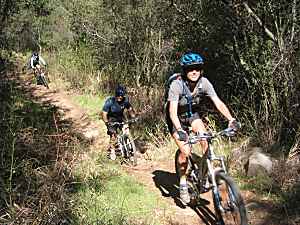 Description This
section of the Backbone Trail is one of the best places to ride
in the Santa Monica Mountains. It's a really fun trail and
it has a great view from the Saddle of the valley through which
it meanders.(The Saddle is the point on Newton Motorway where the
Backbone Trail singletrack crosses it.) You start by descending down a slightly steep (meaning
it's a lot easier on the way out than on the way back!) but well-maintained
and multiuse-wide trail into the valley. After about 1/3 miles you
reach the trees and lose the view but become enveloped in the forest.
At this point the descent is much more gradual. The trail crosses
the seemingly always dry stream a number of times, making for some
fun whoop-de-doos, and except for one, all of them can be ridden
by experienced riders. After a mile and a half you start to climb
out again, but the ascent is moderate except for one or two
short stretches, and there are plenty of twists and turns. When
you get to the Corral Canyon Rd parking area, you can have a short
break and then return the way you came because this trail is just
as fun in both directions, assuming you're up to the steep climb
back to the Saddle. Alternatively, you can return via Castro Motorway
to the top of Bulldog, or continue along Mesa Peak
Motorway to Malibu Canyon Rd and Tapia Park for a much longer ride.
Description This
section of the Backbone Trail is one of the best places to ride
in the Santa Monica Mountains. It's a really fun trail and
it has a great view from the Saddle of the valley through which
it meanders.(The Saddle is the point on Newton Motorway where the
Backbone Trail singletrack crosses it.) You start by descending down a slightly steep (meaning
it's a lot easier on the way out than on the way back!) but well-maintained
and multiuse-wide trail into the valley. After about 1/3 miles you
reach the trees and lose the view but become enveloped in the forest.
At this point the descent is much more gradual. The trail crosses
the seemingly always dry stream a number of times, making for some
fun whoop-de-doos, and except for one, all of them can be ridden
by experienced riders. After a mile and a half you start to climb
out again, but the ascent is moderate except for one or two
short stretches, and there are plenty of twists and turns. When
you get to the Corral Canyon Rd parking area, you can have a short
break and then return the way you came because this trail is just
as fun in both directions, assuming you're up to the steep climb
back to the Saddle. Alternatively, you can return via Castro Motorway
to the top of Bulldog, or continue along Mesa Peak
Motorway to Malibu Canyon Rd and Tapia Park for a much longer ride.
 Description This
trail was closed for a number of years but was opened in mid 2003
after parts of the trail were relocated by the Park Service to make
them more in line with multi-use standards. It's not a very long
trail, but is a nice singletrack and completes the loop back to
Malibu Creek State Park from the Backbone Trail on Mesa Peak Motorway
and single track. The trailhead is deep in Tapia Park, just
before the gate to the Salvation Army Camp. When you get to the
gate (shown at right) turn around and ride back a hundred yards
or so. The trailhead is on the left. From the Malibu Creek Park
end, the trailhead has been relocated and some or all posted maps
show it in the wrong location. You might have to ask a park ranger
for its location. The trail itself is in good condtion and consists
of a moderate climb to the peak, then a moderate descent to the
bottom at the other side. Beginners will probably find it's quite
challenging, but the easy access from both ends may make it a good
practice trail.
Description This
trail was closed for a number of years but was opened in mid 2003
after parts of the trail were relocated by the Park Service to make
them more in line with multi-use standards. It's not a very long
trail, but is a nice singletrack and completes the loop back to
Malibu Creek State Park from the Backbone Trail on Mesa Peak Motorway
and single track. The trailhead is deep in Tapia Park, just
before the gate to the Salvation Army Camp. When you get to the
gate (shown at right) turn around and ride back a hundred yards
or so. The trailhead is on the left. From the Malibu Creek Park
end, the trailhead has been relocated and some or all posted maps
show it in the wrong location. You might have to ask a park ranger
for its location. The trail itself is in good condtion and consists
of a moderate climb to the peak, then a moderate descent to the
bottom at the other side. Beginners will probably find it's quite
challenging, but the easy access from both ends may make it a good
practice trail.

