Trails of
Calabasas
- Trail Descriptions
- Suggested Rides and Hikes
- Geocaches

Looking
west from the Calabasas Crest Trail. The Calabasas Rapids can
be seen to the right.
|
Trails of Calabasas |
||
|
||
|
||
Calabasas has a spider's web of trails with a large number of access points. Many are newer trails and are built to modern standards - smooth singletracks with many switchbacks to limit the steepness. The Calabasas Peak Motorway provides a climbing challenge for everyone, and the Calabasas Historic Trail, close to the 101 Freeway, is part of the missionary route from San Diego to San Francisco, El Camino Real, this section of which became part of the Ventura Highway before it was expanded to the current 101 Freeway. Through the Las Virgenes View Trail, they connect to Malibu Creek State Park to the west. The maps on these pages show some of the Calabasas trails, but not all of them. Yet to be documented for example, is the backbone trail from Malibu Creek State Park to Topanga State Park.
|
Calabasas Trails |

View is from the north-west.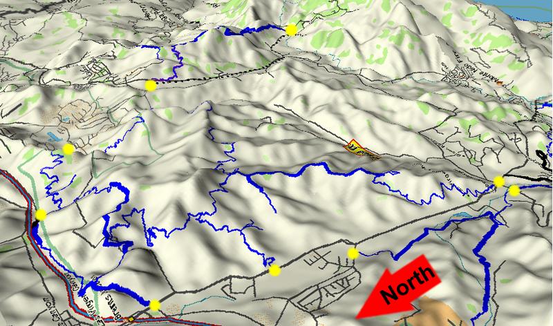
T1 - Las Virgenes View Trail Trailhead and parking on the north-east
corner of Las Virgenes Rd and Mulholland
T2 - Grasslands trailhead
and parking on Mulholland, just west of Las Virgenes Rd
T3 - Bark
Park trailhead and parking on Las Virgenes Rd, about 1 mile south of the 101
freeway
T4 - Grasslands trailhead and parking at De Anza Park on Lost Hills Rd,
just north of Las Virgenes Rd
T5 - Calabasas Rd Trailhead. There is
limited parking here; high ground clearance is needed to get onto the shoulder
T6
- Calabasas Crest Trail trailhead on the south-west end of Calabasas Parkway.
There is no parking here
T7 -
Secret Trail trailhead and parking on Mulholland
T8 - Red Rock Canyon trailhead
on Red Rock Rd, accessed from Old Topanga Canyon Rd. There is parking here for
a fee.
T9 - Calabasas
Peak Motorway trailhead and parking on Stunt Rd, about 1.8 miles from Mulholland
T10
- Calabasas Historic Trail trailhead and parking on Las Virgenes Rd, just south of the 101 freeway
and across the street from Agoura Rd.
 [1] Las
Virgenes View Trail T2
[1] Las
Virgenes View Trail T2
![]()
[1b] Las Virgenes View Park Connector
Trail T2.5
![]()
Description The Las Virgenes View Trail is fantastic trail, well maintained and with some great views; it's only about 2.5 miles long. We use it as an add-on to other rides in the area. It starts at the corner of Mulholland Hwy and Las Virgenes Road, only a couple of hundred yards from where the Grasslands Trail in Malibu Creek State Park crosses Mulholland, and heads north-east. There are a couple of descents, but it generally climbs to a hilltop with almost a 360-degree view of the area. From here it's a really fun downhill back to the start, but be careful because there are a lot of sharp corners with steep dropoffs. Even though the trail is well maintained, it is probably a little too steep for novice mountain bikers to handle, especially if they're not comfortable with steep dropoffs on the side. From the top, it connects to other Calabasas trails via the Las Virgenes View Park Connector, described next
The Las Virgenes View Park Connector Trail connects the top of Las Virgenes View Trail to the New Millennium Loop Trail at the Millennium Trail (heading north-west) and Norman's Way Western Loop Trail (heading south-east). From the top of the Las Virgenes View Trail, you can continue 1.5 miles up this old ridgeline dirt road to the north that looks like it gets used by cattle more than anything else. This road starts with a very steep climb and then undulates up and down some short but steepish hills, sometimes also being loose and sandy. There are a number of barbed-wire gates that cross the road and they can be hard to see - especially the ones at the bottoms of the dips where you want to have some speed to make it up the next hill. There is about 420 feet of climbing and 200 feet of descent to reach the New Millennium Loop Trail.
Download the GPS track ![]() to help you
find your way.
to help you
find your way.
Technical Rating T2
![]() (Las
Virgenes View Trail); T2.5
(Las
Virgenes View Trail); T2.5
![]() (Las
Virgenes View Park Connector Trail)
(Las
Virgenes View Park Connector Trail)
|
Length (miles) |
2.3; 3.8 to the new Millennium Loop Trail |
|
Climb (feet) |
630; 1050 to the new Millennium Loop Trail |
|
Descent (feet) |
160; 360 to the new Millennium Loop Trail |
Trail Profile Back to the Top

New Millennium Loop Trail
T2
![]() to T4
to T4
![]()
Description This loop trail encircles the extravagant New Millennium development and is composed of these segments that are described elsewhere on this page
This loop shares Gun Club Road and part of the Calabasas Crest Trail with the Anza Loop Trail. Except for the dirt Gun Club Road, these trails are all singletrack with a firm and fairly smooth tread. There is lots of climbing to complete this loop and many very tight switchbacks to negotiate. Of special note are the Pyramid Switchbacks and the Too-Tight Switchbacks.
Download the GPS track ![]() to help you
find your way.
to help you
find your way.
Technical Rating T2
![]()
|
Length (miles) |
11.25 |
|
Climb (feet) |
2200 |
|
Descent (feet) |
2200 |
Trail Profile Back to the Top

[2] Bark Park Trail T2
![]()
Description This is a great trail for people who like firm and smooth singletrack with moderate climbs. The trail isn't as steep as Las Virgenes View Trail, but it has enough grade to be lots of fun on the way down! It climbs out of the dog park "Bark Park" on Las Virgenes Road, where there is lots of parking. 0.6 miles from the start is a fork; go left and up. The right fork degrades into a series of dead-end cattle tracks after several hundred yards. At 1.1 miles the trail makes a very sharp left turn where it meets and becomes part of the New Millinnium Loop Trail. Further on, the trail heads down a few gentle switchbacks and looks like it will join Gun Club Rd but instead it climbs up a gentle valley then traverses a steep hill. Eventually it does meet Gun Club Rd, where the trail ends. From there, go downhill a few hundred yards to continue on the Old 101 Trail, or head up Gun Club Rd to get to the Calabasas Crest Trail and continue with the New Millinnium Loop.
Download the GPS track ![]() to help you
find your way.
to help you
find your way.
Technical Rating T2
![]()
|
Length (miles) |
3.2 to Gun Club Rd; 1.1 to the New Millennium Loop Trail |
|
Climb (feet) |
860; 540 to the New Millennium Loop Trail |
|
Descent (feet) |
520; 100 to the New Millennium Loop Trail |
Trail Profile Back to the Top

[3] Gun Club Rd T1
![]()
Description This is an old paved road that still has patches of pavement, but is mostly very firm dirt. It connects the Old 101 Trail, Bark Park Trail and Calabasas Crest Trail. (It get's its name because that's what is shows as on my Garmin GPS, although my Topo program shows a similar road named Warner Brothers Ranch Road.) The Calabasas Crest Trail drops off to the left from the top in a small utility yard just before the fenced community.
When returning down this road, be careful because there is no exit from the bottom onto Las Virgenes Rd. If you overshoot your trail, you'll have to climb back up!
Technical Rating T1
![]()
|
Length (miles) |
1.1; 0.9 from Bark Park Trail to Calabasas Crest Trail |
|
Climb (feet) |
350; 300 from Bark Park Trail to Calabasas Crest Trail |
|
Descent (feet) |
zero |
Trail Profile Back to the Top

[4] Calabasas Crest
Trail T2
![]()
 Description This trail
is very similar to the Bark Park Trail - firm, smooth singletrack with moderate
climbs. In many places you can hear the roar of the Calabasas Rapids, and occassionally
you can see them, too. It starts at the top of Gun Club Rd and drops into a
canyon where it connects with the Calabasas Historic Trail and Calabasas Rd,
then climbs up to a ridge. (There is a ridgeline trail on this ridge that ends
at the top at a fence around someone's back yard.) The Crest Trail drops slightly
into another valley, crosses a rugged wooden bridge, then climbs to the crest
where there's a great view of the Calabasas Country Club and the neighborhoods
behind it. Note that this trail has a number of switchbacks, many that are too
tight to ride. Starting down from the crest you are met by the grandaddy of
all switchbacks, the Too Tight Switchbacks (don't try to ride these!). After
that it's a short hillside traverse to the trailhead on Calabasas Parkway.
Description This trail
is very similar to the Bark Park Trail - firm, smooth singletrack with moderate
climbs. In many places you can hear the roar of the Calabasas Rapids, and occassionally
you can see them, too. It starts at the top of Gun Club Rd and drops into a
canyon where it connects with the Calabasas Historic Trail and Calabasas Rd,
then climbs up to a ridge. (There is a ridgeline trail on this ridge that ends
at the top at a fence around someone's back yard.) The Crest Trail drops slightly
into another valley, crosses a rugged wooden bridge, then climbs to the crest
where there's a great view of the Calabasas Country Club and the neighborhoods
behind it. Note that this trail has a number of switchbacks, many that are too
tight to ride. Starting down from the crest you are met by the grandaddy of
all switchbacks, the Too Tight Switchbacks (don't try to ride these!). After
that it's a short hillside traverse to the trailhead on Calabasas Parkway.
Technical Rating T2
![]() ,
but some switchbacks are too tight to ride
,
but some switchbacks are too tight to ride
|
Length (miles) |
4.2 |
|
Climb (feet) |
570 (from Gun Club Rd, estimated) |
|
Descent (feet) |
670 (estimated) |
Trail Profile Back to the Top

[5] Calabasas - Cold
Creek Connector Trail T2
![]()
Description As of early April, 2007, the connection between the Calabasas Crest Trail and Norman's Way Western Loop Trail is complete, via the Calabasas - Cold Creek Connector Trail! This is another great section of trail with a smooth tread and great views of the surroundings. Some of the sections are a little steep for a multiuse trail, and, as with the other Calabasas trails that surround the New Millennium development along the extension of Calabasas Parkway, the switchbacks are too tight and a real challenge for bikers. That's really only an issue at the north end where the trail climbs the hill from Parkway Calabasas. Towards the south end, the trail goes through a grove of pine trees, and it smells really wonderful.
While riding this trail for the first time, a hawk took off from a tree next to the trail and soared above us. The city of Calabasas uses the hawk for their symbol and it's clear that it's fitting.
Technical Rating T2
![]()
|
Length (miles) |
2.1 |
|
Climb (feet) |
720 (Parkway Calabasas to the Pyramid Switchbacks) |
|
Descent (feet) |
260 |
Trail Profile Back to the Top

[6] Norman's Way Western Loop Trail T4
![]()
Description This trail connects the Calabasas - Cold Creek Connector Trail that ends at the Pyramid Switchbacks to the Las Virgenes View Park Connector trail. It is part of the New Millennium Loop Trail and continues clockwise onto the Millennium Trail. The tread is smooth and in pretty good shape. The section just north-west of the Pyramid Switchbacks is across a very steep slope so there is a lot of exposure, and small landslides can come down from above after heavy rain and partly cover the trail. This section of the trail faces south so it can get very hot in the summer.
November 2012 update: Originally this trail was rated as T2 tread surface
difficulty. However, over the years, the trail has become very narrow where
it crosses some very steep hillsides (see
photos). This is due to slough falling on the trail from above, and from
brush growing up on the inside part of the trail. Because the trail is now so
narrow with severe exposure, I have changed the rating to T4
![]() .
Hikers shouldn't have much trouble, but mountain bikers and equestrians should
use extreme caution here!
.
Hikers shouldn't have much trouble, but mountain bikers and equestrians should
use extreme caution here!
Technical Rating T4
![]()
|
Length (miles) |
2.1 |
|
Climb (feet) |
150 (Pyramid Switchbacks to LV View Park Connector) |
|
Descent (feet) |
530 |
[7] Millennium Trail T2
![]()
Description This is short and smooth singletrack that connects the Bark Park Trail with the Las Virgenes View Park Connector, which itself connects to Las Virgenes View Trail and gives access to Malibu Creek State Park. It completes the New Millennium Loop Trail when traversing it clockwise.
Technical Rating T2
![]()
|
Length (miles) |
0.8 |
|
Climb (feet) |
175 (From LV View Park Connector to Bark Park; estimated) |
|
Descent (feet) |
250 (estimated) |
Trail Profile Back to the Top

Anza Loop Trail T2.5
![]()
Description About a third of this loop follows the Juan Bautista de Anza National Historic Trail parallel to the 101 Freeway. It is made up of these components that are described elsewhere on this page:
This loop is a mixture of singletrack and dirt road. The Calabasas Crest Trail and Gun Club Road are shared with the New Millennium Loop Trail.
Download the GPS track ![]() to help you
find your way.
to help you
find your way.
Technical Rating T2.5
![]()
|
Length (miles) |
3.7 |
|
Climb (feet) |
830 |
|
Descent (feet) |
830 |
Trail Profile Back to the Top

[8] Calabasas Historic Trail
(Juan Bautista de Anza National Historic Trail) T2.5
![]()
Description This trail covers some of the old missionary trail from San Diego to San Francisco, "El Camino Real," part of which became the original Ventura Highway. There are stations along the way that explain the history. It starts from Las Virgenes Rd with a fairly steep fireroad climb (half of the total climbing of this trail is in the first 1/4 mile) and then drops into a slightly swampy area, but one rich with history. It comes out shortly onto Calabasas Rd, or if you take the singletrack bypass, onto a very short section of pavement that leads to the short Calabasas Road Access Trail that connects to the Calabasas Crest Trail.
Download the GPS track ![]() to help you
find your way.
to help you
find your way.
Technical Rating T2.5
![]()
|
Length (miles) |
1.7; 0.4 to the Anza Loop Trail |
|
Climb (feet) |
490; 220 to the Anza Loop Trail |
|
Descent (feet) |
250; none to the Anza Loop Trail |
Trail Profile Back to the Top

[9] Calabasas Road Access
Trail T2
![]()
Description This is a very short trail of about 800 feet that leads from near the south end of Calabasas Road to the Calabasas Crest Trail. Acutally, it ends just short of Calabasas Road at a short paved side-road. Like the other trails in this area, it is a firm, fairly smooth singletrack.
Download the GPS track ![]() to help you
find your way.
to help you
find your way.
Technical Rating T2
![]()
|
Length (miles) |
0.15 |
|
Climb (feet) |
65 |
|
Descent (feet) |
zero |
Trail Profile Back to the Top
Description This is short, smooth and gently climbing singletrack trail that connects Gun Club Rd to Calabasas Historic Trail.
Technical Rating T2
![]()
|
Length (miles) |
0.35 |
|
Climb (feet) |
100 |
|
Descent (feet) |
100 |
 [11] Calabasas Peak
Motorway T1
[11] Calabasas Peak
Motorway T1
![]()
Description This is a climbers delight - wide, firm and steep! There are many interesting sandstone features here, and great views into the valley below. The photo to the right shows the Calabasas Peak Motorway as it looks from above on Stunt Road. There are several trails that connect; all are described elsewhere on this page except the trail about 2.6 miles from the start that leads down to a water tank and then the Mountain Park tennis courts. That trail is fairly steep, but only 1/4 mile long.
When exploring this motorway, I turned around when it started downhill, so it continues further than shown here.
Download the GPS track ![]() to help you
find your way.
to help you
find your way.
Technical Rating T1
![]()
|
Length (miles) |
2.8 or more |
|
Climb (feet) |
1000 |
|
Descent (feet) |
450 |
Trail Profile Back to the Top

[12] Red Rock Road T1
![]()
Description This trail branches off from Calabasas Peak Motorway and goes through some very interesting red sandstone formations in Red Rock Canyon. From Calabasas Peak Motorway, it is just over a mile on dirt before it become pavement, and then it's less than a mile to Old Topanga Canyon Rd. A good novice ride would be to park at the end of the pavement (fee area) and then ride on the pavement back to Old Topanga Canyon Rd, then ride west onto the dirt, then back to the parking.
Download the GPS track ![]() to help you
find your way.
to help you
find your way.
Technical Rating T1
![]() on the dirt, T0
on the dirt, T0
![]() on pavement
on pavement
|
Length (miles) |
1.1 to pavement, 1.9 to Old Topanga Canyon Rd |
|
Climb (feet) |
100 (to Old Topanga Canyon Rd, estimated) |
|
Descent (feet) |
600 (estimated) |
Trail Profile Back to the Top
 [13] Secret Trail
(AKA Calabasas
Cold Creek Trail) T3.5
[13] Secret Trail
(AKA Calabasas
Cold Creek Trail) T3.5
![]()
Description This trail leads from Calabasas Peak Mtwy to Mulholland Highway below. During the spring it's a great place to see wildflowers. It is a multiuse trail, open to all users.
Download the GPS track ![]() to help you
find your way.
to help you
find your way.
Technical Rating T3.5
![]()
|
Length (miles) |
1.5 |
|
Climb (feet) |
200 (estimated) |
|
Descent (feet) |
650 (estimated) |
Trail Profile Back to the Top

This page was last updated January 30, 2017
|
|
Thanks for looking at Steve's guide to trails in Ventura County, the Santa Monica Mountains National Recreation Area (SMMNRA) and other locations. |
|