Trails of
Ventura River Preserve and
Kennedy Ridge in Ojai
Maintained by the Ojai
Valley Land Conservancy

View
of Lake Casitas and part of the Ojai Valley from the Preserve Highpoint on the
Oso Ridge Trail
| Trails of Ventura River Preserve and
Kennedy Ridge in Ojai Maintained by the Ojai
Valley Land Conservancy |
|
This is a beautiful area with very diverse environments that include the bottom of the dry Ventura River, an oak forest, ridgeline chaparral, a great view of the Ojai Valley and Lake Casitas, meadows and an old orange grove.
This area is seasonably accessible because you get to it by crossing the Ventura River, something you don't want to attempt in the winter months when it contains rushing water. Also, this being Ojai, it can get very hot in the summer so late spring and fall are the best times to visit.
During a very rainy winter, the Ventura River can overflow its banks and rearrange the landscape on the flood plain. For that reason, the locations of the River Trails can change from time to time. On the map below, the locations of the River Trails should be thought of as a guideline and not difinitive.
Note: This page is under construction. Some of the descriptions and elevation profiles need to be updated, but the maps are up to date.
Kennedy Ridge Trail
Ventura River Preserve
Trails
a. Riverview Trailhead and parking on Rice Rd. Take the 33 north
from the 101 towards Ojai. At the intersection with Hwy 150 (Baldwin Rd),
about 11 miles from the 101, turn left, then turn right after three blocks onto
Rice Road. Watch carefully for Hwy 150 - it's not well marked. Once on Rice
Road, drive north about 1.5 miles to the Riverview trailhead on the left, across
the street from a large horse coral. It takes about 45 minutes to drive
there from Thousand Oaks. Map
and directions.
b. Oso Trailhead and parking.
From the Riverview Traihead, continue north on Rice Rd about 3/4 miles, then
turn left onto Meyer Rd. The trailhead is at the end of the street. Map
and directions.
c.
Old Baldwin Road Trailhead and parking. From Hwy 33 just south of Ojai, turn
left on Hwy 150 (Baldwin Rd). Drive 0.4 miles and turn right on Old Baldwin
Rd (If you cross the bridge over the river, you've gone too far). Drive to the
end of Old Baldwin Rd., about 0.4 miles. Map
and directions.
Download the GPS tracks ![]() to help you find your way. This GPX file contains tracks for all the trails
in this area.
to help you find your way. This GPX file contains tracks for all the trails
in this area.
Allan Jacobs Trail T2
![]()
Description This is the newest trail in the Ventura River Preserve. It connects the bottom of the Chaparral Crest Trail with Oso Ridge. It's super fun for mountain bikers and had great views of the surrounding mountains and Ojai Valley for everyone! Modern features were used in its construction - for example, climbing turns with substantial outside berms instead of switchbacks.The turns look intimidating when mountain bikers descend them, but they're a lot easier than expected when climbing back up. For hikers (and everyone), this trail provides lots of opportunities to make loop routes.
The trail was built mostly by volunteers in the period 2017-2019. It replaces the connection between the Chaparral Crest Trail and Oso Ridge Trail that was lost when the Chaparral Crest Trail was blocked off about 700' down from the top of the Fern Grotto Trail.
This video shows the trail, starting at about 8:00 minutes in.
Technical Rating T2
![]()
|
Length (miles) |
1.3 |
|
Climb (feet) |
270 (from Chaparral Crest Trail to Oso Ridge Trail) |
|
Descent (feet) |
430 |
Trail Profile Back to the Top

Description The Chaparrel Crest trail starts at the end of Wills Canyon with a fairly steep climb for a half mile. This section can be climbed on a bike, but it's a real challenge. After about 3/4 miles of mostly climbing, the trail makes a switchback left turn onto another road that comes in from the left (the first road continues straight, but that way is closed to the public). Near the top, the Oso Ridge Trail comes in from the south and from there this trail is essentially a ridgeline trail with a few short but steeper climbs and a very steep descent of a couple hundred yards. About 1.8 miles from the top of Wills Canyon, the Fern Grotto Trail drops back down into Wills Canyon. The Chaparral Crest trail continues down and joins the Oso Ridge Trail near the bottom. From the elevation profile below, it doesn't look like the lower section of the trail would be very difficult to climb on a bike, but the reality is completely different under the Ojai sun.
If you think this trail is steep, see how it compares to other steep trails.
Technical Rating Possibly rutted and a little loose, but not very
rocky. T2.5
![]()
|
Length (miles) |
2.9 |
|
Climb (feet) |
600 (Starting at Wills Canyon Trail) |
|
Descent (feet) |
400 to the start of the Fern Grotto Trail; 650 to the Oso Ridge Trail at the bottom |
Trail Profile Back to the Top

 Description This singletrack is
a beautiful trail that connects the Wills Canyon Trail just south of the Chaparral
Crest Trail with the Rice Canyon Trail just about where it starts to climb out
of Wills Canyon. The trail starts at the little bridge bypass trail and has
a bit of a rocky start with a very short climb, but then it becomes a smooth,
leaf-littered trail. The forest here has very little undergrowth so everything
seems very open. The trail soon emerges into a small meadow and meanders across
before it joins up with the Rice Canyon Trail. This is one section you
should not miss!
Description This singletrack is
a beautiful trail that connects the Wills Canyon Trail just south of the Chaparral
Crest Trail with the Rice Canyon Trail just about where it starts to climb out
of Wills Canyon. The trail starts at the little bridge bypass trail and has
a bit of a rocky start with a very short climb, but then it becomes a smooth,
leaf-littered trail. The forest here has very little undergrowth so everything
seems very open. The trail soon emerges into a small meadow and meanders across
before it joins up with the Rice Canyon Trail. This is one section you
should not miss!
Technical Rating T2
![]()
|
Length (miles) |
0.35 |
|
Climb (feet) |
60 (travelling north-west) |
|
Descent (feet) |
30 |
Description This trail leads from the Chaparral Crest Trail down to Wills Canyon. The top is in the chaparral, but the bottom 2/3 is under the tree canopy of Wills Canyon and it makes for a very pretty and shady route. This is a really fun downhill for mountain bikers. The profile is shown as part of the Chaparral Crest Trail profile, above.
Technical Rating T3
![]()
|
Length (miles) |
0.3 |
|
Climb (feet) |
0 (Starting at Chaparral Crest Trail) |
|
Descent (feet) |
225 |
Trail Profile is above, with the Chaparral Crest Trail profile. Back to the Top
Kennedy Ridge Trail
and
Kennedy Ridge Junction Trail
 Description The
Kennedy Ridge Trail is a work in progress. It starts in the Ventura River Preserve
and climbs up to Kennedy Ridge, crosses down to Kennedy Canyon, then climbs
to the old Camino Cielo road. This is where the work in progress comes
in to play. El Camino Cielo has 20 years or more of brush growing on it, so
the trail is being extended north-westerly (uphill) one section at a time by
cutting back the brush. Some sections are wide and clear, but others, not so
much. Sections that are well cut back are interspersed with much narrower sections.
Eventually the trail will connect with the Oceanview Trail and Divide Peak.
Description The
Kennedy Ridge Trail is a work in progress. It starts in the Ventura River Preserve
and climbs up to Kennedy Ridge, crosses down to Kennedy Canyon, then climbs
to the old Camino Cielo road. This is where the work in progress comes
in to play. El Camino Cielo has 20 years or more of brush growing on it, so
the trail is being extended north-westerly (uphill) one section at a time by
cutting back the brush. Some sections are wide and clear, but others, not so
much. Sections that are well cut back are interspersed with much narrower sections.
Eventually the trail will connect with the Oceanview Trail and Divide Peak.
Overall, the entire trail is very easy to follow and there are spectacular
views as you climb higher. Several picnic tables have been hauled up and placed
at good viewpoints. Most of the trail has a smooth, single-track width tread
(T2
![]() )
but on Camino Cielo, there are some rockfalls and screefalls that cover the
trail (T4.5
)
but on Camino Cielo, there are some rockfalls and screefalls that cover the
trail (T4.5 ![]() ).
).
This moderatley steep trail is a great hike for intermediate and more experienced hikers. Even though it's open to mountain biking, it's really too steep, and in many places, too rugged to ride enjoyably. By the time you hike it, the sections that are a little narrow or rugged may have been fixed up and it may push all the way through to Divide Peak!
View a Kennedy Ridge Trail photo Gallery.
|
Length (miles) |
6.25 |
|
Climb (feet) |
2550 |
|
Descent (feet) |
120 |

Description This is a gravel and dirt road that descends gently from Rice Canyon, then bears right through the orange grove to get to the bottom of Wills Canyon. This is a very easy trail and a pleasant end to the Wills Canyon / Rice Canyon loop.
Download the GPS track
![]() to help you find your way.
to help you find your way.
Technical Rating T1
![]()
|
Length (miles) |
0.6 |
|
Climb (feet) |
20 |
|
Descent (feet) |
30 |
Trail Profile is above with the Wills Canyon Trail Back to the Top
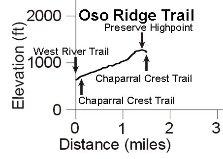
Description This is a mostly ridgeline trail with some great views, particularly to the south. Being ridgeline, it has some steep sections that can get loose if it hasn't rained for some weeks. A very strong rider will be able to ride up most of the way, but this trail typically involves some pushing on the way up. Near the top, the trail turns away from the ridgeline and follows a very trecherously loose singletrack with a few very tight switchbacks. At the top of the switchbacks is the Preserve Highpoint where there is a really great view of the valley to the south and Lake Casitas. From there it's a short way to the Chaparral Crest Trail. On the way down, this is a super fun trail to ride once you're past the loose singletrack at the top.
Technical Rating Ridgeline section, T3
![]() .
Singletrack switchback, T4.5
.
Singletrack switchback, T4.5 ![]()
|
Length (miles) |
1.5 |
|
Climb (feet) |
680 |
|
Descent (feet) |
90 |
Trail Profile Back to the Top
Description The exact starting point of the Rice Canyon Trail is a little uncertain, so for simplicity I have it starting when the trail starts to climb out of Wills Canyon at the Chaparral Crest Trail. The trail also becomes a proper fireroad, with a gentle climb at first and that gets a little steeper towards the top. At the peak there's a great view back down into the top of Wills Canyon. The road forward and down is a decent fireroad, perhaps a little loose and rocky in spots. About 1.6 miles from the start of the climb out of Wills Canyon, the trail takes a sharp right turn off the fireroad and continues downhill on a singletrack, through trees and meadows before coming out at the canal. A small wooden bridge to the right leads to the Orange Grove Trail.
Technical Rating Fireroad, T1.5
![]() .
Singletrack, T2
.
Singletrack, T2
![]()
|
Length (miles) |
2.2 |
|
Climb (feet) |
340 |
|
Descent (feet) |
470 |
Trail Profile is above with the Wills Canyon Trail Back to the Top
Description To get to the Preserve trails you need to take one of these trails to get to the west side of the river. They go through the bottom of the dry riverbed, and they're rocky, sandy and, in the better sections, gravelly! If you're riding, most people will push or carry their bikes for most of these trails. Special note: The West River Trail goes through the middle of the riverbed, not along the side of it, so it is an especially long challenge. They are all, however, mostly flat.
|
[3] North River Crossing |
0.1 miles long T4.5 |
|
[2] Wills Crossover |
0.15 miles long T4.5 |
|
[4] West River Trail |
0.55 miles long T4.5 |
|
[13] South River Trail |
0.33 miles long T2.5
|
|
[14] Green Chair Trail |
0.3 miles long T2.5
|
Upper River Loop Trails (AKA Riverview Loop Trails)
Description There are a number of trails on the east bank of the Ventura River that connect the two northern trailheads and the three river crossings. They are generally pretty level, smooth and firm, but there are occassional short rocky sections. Not all of these trails are shown on the map above.
Technical Rating T2.5
![]()
Description This is a newer section of the Preserve, opened in 2011, connecting to the Old Baldwin Road trailhead. The eastern arm of the loop is along a wide grassy walkway that passes along the back of the neighboring houses. The western arm is a singletrack that meanders along the flood plain. There are several trails that connect these two halves of the loop, but they're not shown on the map. There is very little elevation change along these trails.
Technical Rating T2
![]()
|
Length (miles) |
1.3 (1.6 including the ADA Accessible Trail) |
|
Climb (feet) |
40 |
|
Descent (feet) |
40 |
Description This is a beautiful old dirt road that has degraded to a wide and very easy singletrack. It goes through an old oak forest, but stay on the trail because there is a lot of poison oak under those trees! The trail starts at the end of the Wills Crossover (AKA mid river crossing). Cross the paved canal road to start on a singletrack that parallels the road, drops into a creek and then climbs steeply out. At the top of the creek bank, the Wills Canyon Trail is to the left (uphill) and the Orange Grove Trail is to the right. A lovely and easy loop to do is to go west up Wills Canyon, continuing up the ridge and over into Rice Canyon, down the fireroad and onto the singletrack, turning south on the Orange Grove Trail, finally bearing right through the orange grove to get back to the start of Wills Canyon. The profile below shows this whole loop. This is a great loop because of the gentle climb up Wills Canyon, the fun downhill in Rice Canyon which ends on singletrack, and then the River Bluff Trail runs along next to an abondoned orange orchard before running through the trees. The variety of surroundings on this loop is amazing!
Download the GPS track ![]() to help you find
your way.
to help you find
your way.
Technical Rating T2
![]()
|
Length (miles) |
1.5 (Wills Canyon Trail only) |
|
Climb (feet) |
250 |
|
Descent (feet) |
60 |

This page last updated on March 23, 2023
|
|
Thanks for looking at Steve's guide to trails
in Ventura County, the |
|
 Chaparral Crest Trail
 Oso Ridge Trail
 Lower River Loop Trails
 Wills Canyon Trail