Trails of
Romero Canyon in Santa Barbara
- Trail Descriptions
- Suggested Rides and Hikes
- Geocaches

Looking
down Romero Canyon from the Romero Canyon Road
|
Trails of Romero Canyon in Santa Barbara |
||
|
||
|
|
||
Romero is a lush canyon above Summerland, just south-west of Santa Barbara. There are two trails - a fireroad that provides a fairly gentle climb and great views of the canyon out to the coast. The trail is steeper but runs next to the stream for the first half, mostly in the shade of oak and sycamore trees. It crosses the road midway up and climbs switchbacks, now providing stunning views of the area.
This area is popular with both mountain bikers and hikers. However, the limited parking at the bottom restricts access for equestrians.
The tread and width of the road varies from year to year. When brush fires threaten the region, it is graded out to a full fireroad and will be wide and smooth for a year or more afterwards. But the steepness and lushness of the canyon soon results in fallen rocks of all sizes scattered over the road and vegetation growing in from the sides. In a couple of years the road can change from a broad, wide road to a twisty and very rocky singletrack.
The Romero Canyon road is about 7 miles of a fairly constant and moderate climb along an overgrown fire road. The trail has a number of low-hanging bushes that sometimes force you into an undesireable path when climbing, and the surface is littered with loose rocks about the size of golf balls to oranges. Otherwise it is generally quite firm. On the way up you will have plenty of time to take in the spectacular views as the trail alternates between overlooking the coast and Romero Canyon as in the photo above. On the way down you'll be focused to the trail about 20 feet in front of you, thankful that you saved up for that soft-tail frame (you do have full suspension, don't you?)!
View of Romero Canyon from the north.
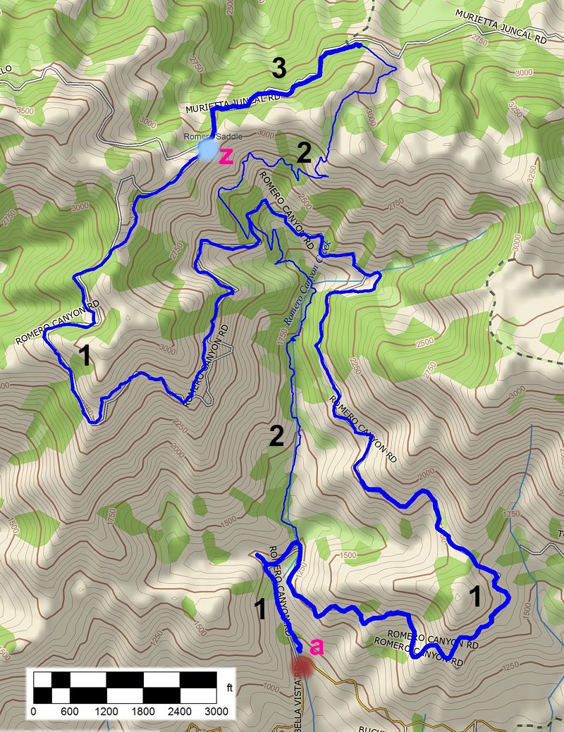
a. Bella Vista Drive, where you park at the side of the road. From the 101 Freeway, take the Sheffield exit in Summerland, just west of the Big Yellow House Restaurant. At the end of the off-ramp, turn north and proceed to East Valley Rd. At East Valley Rd make a left and then a quick right onto Romero Cyn Rd. Stay on Romero Cyn Rd until you come upon Bella Vista Dr. At Bella Vista make a right and continue up approximately � mile to the trailhead. Map and directions
|
|
Description The Romero Canyon Road is an old fire road that climbs steadily from Bella Vista Drive for just over 6 miles before heading down for a half mile to the Romero Saddle at the junction of Camino Cielo and Murietta Juncal Road, two dirt roads. About 4.3 miles from the bottom the road is crossed by the Romero Cyn Trail in the shade of a huge tree. There isnn't much shade, but there are great views to the ocean on the way up and you occasionally see a paraglider sailing on the updrafts. At the top, there is a widening of the trail and an overgrown trail straight ahead. The road turns to the right and heads downhill.
The road is actively used for fire control and is graded in times of fire danger. Between gradings, it can become quite narrrow, twisty and rocky as rocks fall on it from above. As of spring 2010, the road is broad and generally smooth, but there are places where rocks have fallen down from above. There is a clear well-travelled track about 2' wide that wanders between the fallen rocks. In time, this trail will again become very rocky but the tread remains pretty firm.
When the trail is narrow and rocky, mountain bikers love this road. It's not so much fun when it's broad and smooth. From the top, expert mountain bikers may want to try the steeper and narrow Romero Canyon Trail back down. It's more technical than the road, particularly on the lower half.
There is a box of handlebar bells at the bottom that mountain bikers can use to warn hikers of their approach.
If you think this trail is steep, see how it compares to other steep trails.
Download the GPS track
![]() to help you find your way.
to help you find your way.
Technical Rating T1
![]() to T4.5
to T4.5 ![]() ,
depending on how long since it was last graded
,
depending on how long since it was last graded
|
Length (miles) |
6.8 |
|
Climb (feet) |
2500 (estimated) |
|
Descent (feet) |
500 (estimated) |
Trail Profile Back to the Top

[2] Romero Canyon Trail
 Description The
lower section of this trail is very popular with hikers because it follows along
a beautiful creek and is in almost constant shade from large trees. It starts
near the bottom of Romero Canyon Road, just under a half mile from the Bella
Vista Drive trailhead. It follows along beside the creek for about a mile, crossing
from one side to the other a few times. It is moderately steep and has much
smooth and firm tread, but it is very rocky in sections and has some near vertical
drops of 20' or more into the creek at the edge of the trail.
Description The
lower section of this trail is very popular with hikers because it follows along
a beautiful creek and is in almost constant shade from large trees. It starts
near the bottom of Romero Canyon Road, just under a half mile from the Bella
Vista Drive trailhead. It follows along beside the creek for about a mile, crossing
from one side to the other a few times. It is moderately steep and has much
smooth and firm tread, but it is very rocky in sections and has some near vertical
drops of 20' or more into the creek at the edge of the trail.
After a mile, the trail climbs away from the creek and heads to the road, crossing it after another half mile.
Some expert mountain bikers like to ride down the lower half of this trail after riding up the road, so be on the lookout for them!
The upper half of the trail starts where it crosses Romero Cyn Road. It is similar to the last half mile of the lower section in that the trees give way to mostly chaparral which does not block the view down the canyon and to the coast. The trail is about as steep as the lower half, but there are long sections where the tread is much looser because it is made up of scree.
There are two ways to connect back to Romero Canyon Road from the top. About 1.2 miles up the upper section, the trail crosses the ridgeline Camino Cielo. You can turn west left (north-west) there and continue to the Romero Saddle, or continue another half mile to Murietta Juncal Rd and then hike up it to the saddle.
A favorite hike route is to hike up the Romero Cyn Trail to the top and then take the dirt road down. A shorter variation would be to just hike the lower trail to Romero Canyon Road, then hike down the road back to the bottom.
Download the GPS track
![]() to help you find your way.
to help you find your way.
Technical Rating Lower half: T5
![]() ;
Upper half: T4
;
Upper half: T4
![]()
|
Length (miles) |
3.0; 1.5 from the bottom to Romero Canyon Road |
|
Climb (feet) |
2000 (estimated); 1100 from the bottom to Romero Canyon Road |
|
Descent (feet) |
400 (estimated) |
Trail Profile Back to the Top

Description This is a dirt road that continues from the end of Romero Canyon Road (at Romero Saddle) down the back side of the moutains. It connects to the north end of the Romero Canyon Trail, then continues down past Forbush Creek to Santa Ynez River and beyond.
Download the GPS track
![]() to help you find your way.
to help you find your way.
Technical Rating T1.5
![]()
|
Length (miles) |
0.65 to Romero Cyn Trail trailhead |
|
Climb (feet) |
little or none (estimated) |
|
Descent (feet) |
250 (estimated) |
This page last updated on February 18, 2010
|
|
Thanks for looking at Steve's guide to trails in Ventura County, the Santa Monica Mountains National Recreation Area (SMMNRA) and other locations. |
|
