Trails of
Upper Las Virgenes Open
Space Preserve
(aka Ahmanson Ranch)
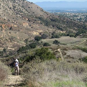
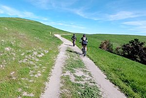
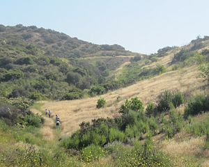
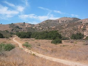
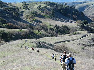
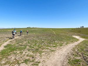
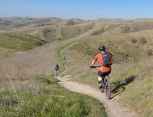
Ahmanson Ranch from near the bottom of Switzerland.
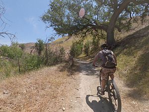
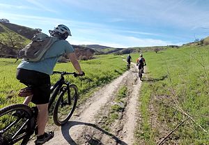
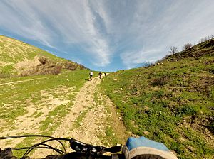
Ahmanson Ranch (here its historical name is used because the formal name is too much of a mouthful) is a beautiful property of rolling grasslands studded with many oak trees. There are a few official trails (shown in blue on the map below) but many more unofficial trails (dashed brown lines). For the most part, the unofficial trails are much more beautiful to hike and fun to ride.
The descriptions of the many, mostly short, trails in the wedge-shaped area between Ahmanson Ranch House Road, East Las Virgenes Canyon Trail and Crazy Snake (the "South-East Social Trails) are described in a section near the bottom of this page.
Unhappily, much of the grasslands have been taken over by mustard so the trails can become clogged in the spring. Also, it's really hot here in the summer so pay close attention to the weather forecast and how much water you have before heading out.
For a number of years, Ahmanson Ranch was a controversial piece of land because Washington Mutual Bank wanted to build 3000 homes here, a golf course and shopping plaza. Besides the concerns about congestion from the extra traffic on the 101 freeway and Valley Circle Rd, this area is home to two endangered species. In 2004 the bank instead sold the land to the state for a park and now it is open for riding and hiking. The propery is owned and managed by the Mountains Recreation Conservation Agency (MRCA).
Determining the names of all the trails was not easy because of contradictions on even the official maps. Here most of the unofficial trails are named as they are in TrailForks but maps for official land managers are used for the official trails.
|
|

Unofficial Sites
Trailheads, Parking and Features
a. Main parking area at the west end of Victory Blvd. There is a fee
to park here. Map
and directions.
b. Near the west end of Victory Blvd, just east
of Gilmore St. Parking at the side of the road is free. Map
and directions.
c. North end of Las Virgenes Road. Free
parking at the side of the road. Map
and directions.
d. The entrance to El Escorpion Park at the
junction of Van Owen and Sunset Ridge Ct. Park at the side of the road. Map
and directions.
e. Anfractuous Trailhead on at the end of
Edenpark Dr. Map
and directions.
Download the GPS tracks ![]() to help you find your way. This GPX file contains tracks for all the trails
in this area.
to help you find your way. This GPX file contains tracks for all the trails
in this area.
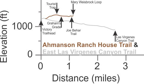
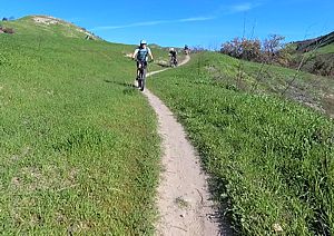
 Ahmanson Ranch House Trail
T1.5
Ahmanson Ranch House Trail
T1.5
![]()
Description This fire road lleads from East Las Virgenes Canyon Trail, 350 yards west of the Victory trailhead, to the Mary Wiesbrock Loop. It starts with a moderate climb for the first third of a mile, and then becomes very gently rolling. It gives access to the super-fun mountain biking downhill run known as Graham's Grade.
Watch this video, starting at 0:31 to see some of this trail.
Technical Rating T1.5
![]()
|
Length (miles) |
1.0 |
|
Climb (feet) |
190 (from East LV Canyon Trail to Mary Weisbrock Loop) |
|
Descent (feet) |
90 |
Trail Profile Back to the Top
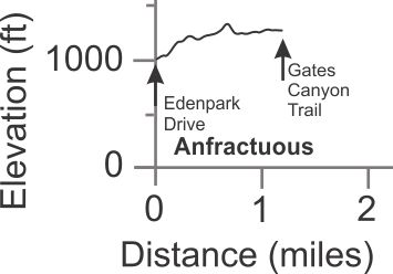
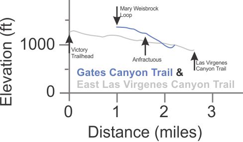
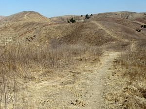 Anfractuous
(aka
Edenpark Trail) T2.5
Anfractuous
(aka
Edenpark Trail) T2.5
![]()
Description This is moderatly used singletrack trail that leads from the neighborhood around Edenpark Drive in Calabasas to the Gates Canyon Trail in the park proper. It has some very steep sections and is probably overgrown with weeds in the spring. The steepest hill (a little uphill of the center of the trail) changes elevation of 100' over 460'.
Technical Rating T2.5
![]()
|
Length (miles) |
1.2 |
|
Climb (feet) |
400 (Edenpark Drive to Gates Canyon Trail) |
|
Descent (feet) |
130 |
Trail Profile Back to the Top
 Castle Peak Trail
(AKA Valley View and Easy Rider) T3
Castle Peak Trail
(AKA Valley View and Easy Rider) T3
![]()
Castle Peak Ridge (AKA Valley View and Rocky
Road) T5
![]() HO
HO
![]()
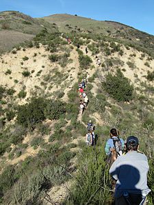
Description These two trails lead to Castle Peak, a difficult rocky formation that provides stunning views of the San Fernando Valley. If you're up to it, this is a destination worth hiking to! The route starts below Castle Peak on El Escorpion Trail, then onto Scotland for 320 yards. The trail that heads uphill is the Castle Peak Trail. After a half mile of a fairly steep climb, the Castle Peak Ridge trail splits off to the right and heads along the rocky ridgeline. The Castle Peak Trail continues up a valley, a little less steeply, running parallel to the ridge. Eventually it ends at the Castle Ridge trail where some rock scrambling will be required to make it to the overlook at the east end. If you're up to a little rock scrambling, the ridgeline trail is much more interesting. The photo below on the left shows what it's like. Both trails are too steep and/or rocky for mountain biking.
|
Length (miles) |
Castle Peak Tr: 0.82; Castle Ridge: 0.5 |
|
Climb (feet) |
Castle Peak Tr: 520; Castle Ridge: 200 |
|
Descent (feet) |
Castle Peak Tr: 60; Castle Ridge: 200 |
 Trail Profile Back to
the Top
Trail Profile Back to
the Top
 Cave of the Munits Trail
T5
Cave of the Munits Trail
T5
![]() HO
HO
![]()
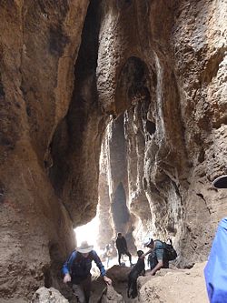
Description The Cave of the Munits is a large and very popular destination. You can climb through it to get to the Castle Peak Ridge Trail above it. The trail starts on El Escorpion and after about 300 yards, the approach gets quite steep, requiring a little rock climbing to get into the cave. Take a look at this photo gallery to see what it's like. More climbing up the rock faces inside the cave will get you to the top where you can exit to the hillside above. From there, it's more scrambling up a steep trail to get to the Castle Ridge Trail. If you enjoy scramblling up steep rock faces, you'll love this trail!
Overall the trail is very steep - it climbs 450' in 0.3 miles; most of that is in the second half (0.15 miles)
|
Length (miles) |
0.2 to the cave from El Escorpion; 0.15 from the cave to Castle Ridge Trail. |
|
Climb (feet) |
450 |
|
Descent (feet) |
None (unless you fall - be careful!) |
This trail is too short to provide an elevation profile. Back to the Top
 Coyote Trail
T2
Coyote Trail
T2
![]()
Description This is a super-fun mountain biking singletrack trail that starts at the North Las Virgenes Canyon Access Road (NLVCAR) at the top, and ends at the East Las Virgenes Canyon Trail. A trail on the other side of the E. LV Cyn Trail and paralllel to it (Las Virgenes Singletrack) continues down almost to the junction with the Las Virgenes Canyon Trail.
Watch this video, starting at 4:42 to see some of this trail from the top. In the spring, the trail can become completely overgrown with mustard and other weeds, and is swampy in couple of short sections.
Technical Rating T2
![]()
|
Length (miles) |
0.7 |
|
Climb (feet) |
None (from NLVCAR to ELVCT) |
|
Descent (feet) |
160 |
This trail is too short to provide an elevation profile. Back to the Top
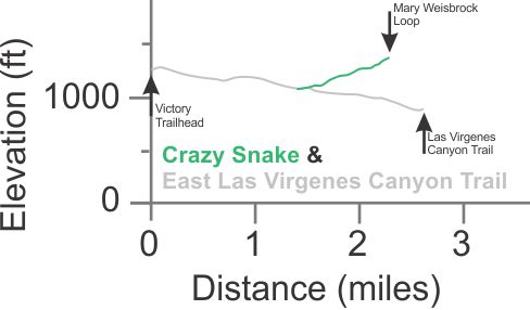
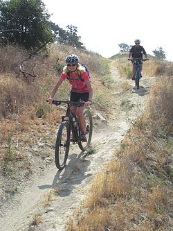 Crazy Snake
T2.5
Crazy Snake
T2.5
![]() (or T3.5
(or T3.5
![]() if you ride down it fast!)
if you ride down it fast!)
Description This is a fun downhill singletrack trail for mountain bikers that runs from the Mary Wiesbrock Loop at the top, crosses Laskey Mesa Trail near the bottom and ends at East Las Virgenes Canyon Trail. It has some ruts; it's very uneven in places and has a bit of exposure. The tread is mostly firm. There is no shade.
Mountain bikers should remember that hikers and equestrians also use this trail and display proper trail etiquette by slowing to a crawl to pass them.
Watch this video, starting at 2:31 to see some of this trail starting at the top.
Technical Rating T2.5
![]()
|
Length (miles) |
0.8 |
|
Climb (feet) |
15 (from Mary Wiesbrock Loop to East LV Canyon Trail) |
|
Descent (feet) |
305 |
Trail Profile Back to the Top
Downtown T1
![]()
Downtown is a trail at the top of a steep ridge near the Victory Blvd. trailhead. It continues onto England at the west end and can be accessed thereby, or up the very steep Jolly or Push It trails that gain 100' in 0.1 miles. It is very firm and broad.
This trail is too short to provide an elevation profile. Back to the Top
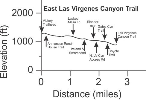
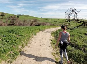
 East Las Virgenes Canyon Trail
T1.5
East Las Virgenes Canyon Trail
T1.5
![]()
Description This is the main trail running through the area, and as such, it has a lot of visitors on it. It's an old ranch road and so is quite wide, but it doesn't get any maintenance so over the years it's getting narrower and developing some ruts. As of 2022, it's mostly doubletrack width.
Technical Rating T1.5
![]()
|
Length (miles) |
2.6 |
|
Climb (feet) |
50 (From the Victory Blvd. trailhead, heading southwest) |
|
Descent (feet) |
430 |
Trail Profile Back to the Top
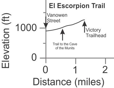
 El Escorpion Trail
(AKA Juan Bautista de Anza National Historic Trail; Hunter Allen
Trail)T1.5
El Escorpion Trail
(AKA Juan Bautista de Anza National Historic Trail; Hunter Allen
Trail)T1.5
![]()
Description This trail is firm and wide; for the most part it's a doubletrack. It connects the trailhead at Vanowen Street, right where it turns onto Sunset Ridge Court, to East Las Virgenes Canyon Trail at the Victory trailhead. Along the way it connects to a number of trails that lead to interesting places.
Technical Rating T1.5
![]()
|
Length (miles) |
1.3 |
|
Climb (feet) |
350 |
|
Descent (feet) |
Zero |
Trail Profile Back to the Top
Description This singletrack connects East
Las Virgenes Canyon Trail (ELVCT) to El Escorpion
in a sort-of sideways "U" shape. It's highest in the middle where
it connects to Upper England; the climbs from both
sides are pretty steep, but the end from ELVCT can be climbed by strong mountain
bikers. This half is rated T3
![]() because of the steepness, but the tread is pretty firm. On the other hand,
the steeper northeast end is loose and rutted, and fun for only very good mountain
bikers to ride down and rated T4
because of the steepness, but the tread is pretty firm. On the other hand,
the steeper northeast end is loose and rutted, and fun for only very good mountain
bikers to ride down and rated T4
![]() .
Expect the entire trail to be overgrown in the spring with mustard and other
weeds.
.
Expect the entire trail to be overgrown in the spring with mustard and other
weeds.
Watch this video, starting at 0:27 to see the bottom of England.
|
Length (miles) |
0.56 (From Upper England to E. LV Canyon Trail) 0.54 (From Upper England to El Escorpion) |
|
Climb (feet) |
40 (From Upper England to E. LV Canyon
Trail) 40 (From Upper England to El Escorpion) |
|
Descent (feet) |
270 (From Upper England to E. LV Canyon
Trail) 400 (From Upper England to El Escorpion) |
Trail Profile Back to the Top
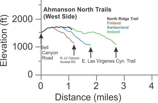
 Finland (AKA
Nepal)
T2.5
Finland (AKA
Nepal)
T2.5
![]()
Description This is a very steep singletrack that gives access to the North Ridge Trail from Slenderman. If you're riding, expect to push your bike up at least part of it. The tread is firm but likely overgrown in the spring with mustard.
View the trail in this video, starting at 0:14.
Technical Rating T2.5
![]()
|
Length (miles) |
0.875 |
|
Climb (feet) |
35 (From North Ridge Trail down to Slenderman) |
|
Descent (feet) |
570 |
Trail Profile Back to the Top
Description This trail connects the Mary Wiesbrock Loop
on the west side to the East Las Virgenes Canyon Trail
0.3 miles from the southwest end. It's mostly broad dirt road T0.5
![]() because
it's used to access the gas pipeline that goes through the area. However, a
quarter mile near the west end has narrowed to a singletrack T2.5
because
it's used to access the gas pipeline that goes through the area. However, a
quarter mile near the west end has narrowed to a singletrack T2.5
![]() .
There is some shade along the singletrack, but has a big rut as
you climb just before you get to the fireroad part.
.
There is some shade along the singletrack, but has a big rut as
you climb just before you get to the fireroad part.
Technical Rating T0.5
![]() for
the top 60%; T2.5
for
the top 60%; T2.5
![]() for the bottom 40%
for the bottom 40%
|
Length (miles) |
1.2 |
|
Climb (feet) |
450 (from East LV Canyon Trail to Mary Weisbrock Loop) |
|
Descent (feet) |
50 |
Trail Profile Back to the Top
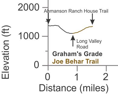
 Graham's Grade
T2.5
Graham's Grade
T2.5
![]()
Description From Ahmanson Ranch House Trail, Graham's Grade is a singletrack for about 1/3 miles. Then it widens to a doubletrack with many big ruts on one side or the other. It's super fun to blast down on a mountain bike, ending at the Joe Behar Trail near Long Valley Road. In the spring it will be overgrown by long grass that hides the ruts, so be careful!
Watch this video, starting at 1:01 to see some of this trail, unnamed at the time the video was made.
Technical Rating T2.5
![]()
|
Length (miles) |
0.8 |
|
Climb (feet) |
30 (from Ahmanson Ranch House Trail heading down) |
|
Descent (feet) |
290 |
Trail Profile Back to the Top
 Ireland
T3
Ireland
T3
![]()
Description This is one of two really fun downhill trails for mountain bikers (the other being Switzerland) but it's not for beginners! Both these trails start at North Ridge Trail and end at East Las Virgenes Canyon Trail. Ireleand is mostly firm but some sections have loose rocks. It will be overgrown with weeds in the spring, mostly mustard.
View the trail in this video, starting at 1:24.
Technical Rating T3
![]()
|
Length (miles) |
1.8 |
|
Climb (feet) |
110 (From North Ridge Trail to E. LV Canyon Trail) |
|
Descent (feet) |
740 |
Trail Profile Back to the Top
 Joe Behar Trail
T2.5
Joe Behar Trail
T2.5
![]()
Description This singletrack trail climbs from the bottom of Graham's Grade back up to the Ahmanson Ranch House Trail (ARHT), just before it ends at the Mary Wiesbrock Loop. It's generally pretty firm but has some small ruts and little steps to make it more entertaining.
Watch this video, starting at 2:19 to see some of this trail. See a blog about Joe Behar here to learn why he deserved to have a trail named after him.
Technical Rating T2.5
![]()
|
Length (miles) |
0.7 |
|
Climb (feet) |
240 (From Graham's Grade to ARHT) |
|
Descent (feet) |
zero |
Trail Profile Back to the Top
Jolly T3.5
![]()
Description This is a very steep singletrack trail, dusty and somewhat loose and rutted. It splits off from England to climb straight up the hill to Downtown. The change in elevation is 120' over 0.12 miles (650').
Technical Rating T3.5
![]()
|
Length (miles) |
0.12 |
|
Climb (feet) |
120 (From England to Downtown) |
|
Descent (feet) |
zero |
This trail is too short to provide an elevation profile. Back to the Top
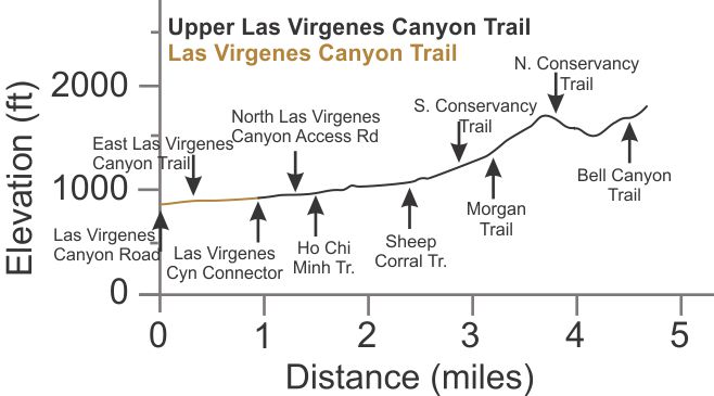
 Las Virgenes Canyon Trail
T1.5
Las Virgenes Canyon Trail
T1.5
![]()
Upper Las Virgenes Canyon Trail
T1.5
![]()
(aka
East Las Virgenes Canyon Trail; Bell Canyon Trail)
Description This is the main route through Las Virgenes Canyon (LVC). Mostly it's a decent dirt road, but it does narrow at places down to a doubletrack, and even has a singletrack section to bypass a perpetual mud hole. In the rainy season, there will be some puddles that need to be forded, and possibly even places where the road has been completely washed away by a small stream that crosses it.
The LVC Trail becomes the Upper LVC Trail as you travel north from Las Virgenes Canyon Road, but the official maps disagree on where the transition occurs.
Little Sketchy and Ho Chi Minh trails run parallel to LVC Trail and uphill to the west for the southern-most 1.5 miles. They are much more interesting, but also more technical and so more difficult.
Watch this video, starting at 9:16 to see some of the LVC trail.
Technical Rating T1.5
![]()
|
Length (miles) |
4.5 from Las Virgenes Road to Bell Canyon Trail |
|
Climb (feet) |
1100 |
|
Descent (feet) |
275 |
Trail Profile Back to the Top
 Las
Virgenes Singletrack T2
Las
Virgenes Singletrack T2
![]()
Description There are a few singletrack segments that run parallel and close to the East Las Virgenes Canyon Trail, just to the south-east. They start just north of the junction with the Gates Canyon Trail and continue almost to the junction with the Las Virgenes Canyon Trail. These are generally firm trails, gently downhill, and very fun to descend on a mountain bike.
Watch this video, starting at 6:24 to see some of this trail.
Technical Rating T2
![]()
|
Length (miles) |
0.5 |
|
Climb (feet) |
10 (from north to south) |
|
Descent (feet) |
130 |
This trail is too short to provide an elevation profile. Back to the Top
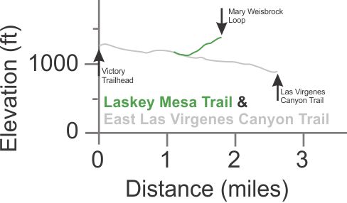
 Laskey Mesa Trail
T2
Laskey Mesa Trail
T2
![]()
Description This is an old ranch road, now mostly a doubletrack, that is moderately steep, climbing from the East Las Virgenes Canyon Trail to the Mary Wiesbrock Loop and Gates Canyon Trail. It doesn't get much maintenance, if any, so ruts that develop just get bigger over time.
Technical Rating T2
![]()
|
Length (miles) |
0.7 |
|
Climb (feet) |
250 (From ELVC Trail to Gates Canyon Trail) |
|
Descent (feet) |
50 |
Trail Profile Back to the Top
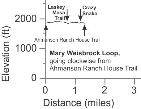
 Mary Wiesbrock Loop
T1
Mary Wiesbrock Loop
T1
![]()
Description This is another old ranch road. It is slightly hilly and gets a decent amount of use. From the mountain bikers' perspective, it is mostly used to give access to two fun singletracks, Crazy Snake and Up and Over.
See a blog about Mary Wiesbrock to learn why she deserved to have a trail named after her.
Technical Rating T1
![]()
|
Length (miles) |
1.3 |
|
Climb (feet) |
100 |
|
Descent (feet) |
100 |
Trail Profile Back to the Top
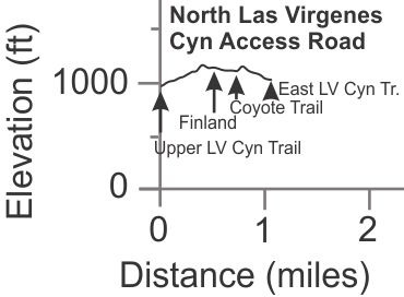
 North Las Virgenes Canyon Access Road
T2
North Las Virgenes Canyon Access Road
T2
![]()
Description This fireroad provides access between Las Virgenes Canyon Trail and East Las Virgenes Canyon Trail. It gets graded every few years, so you never know if it will be full width, or narrowed down to almost a singletrack. In the middle, it's quite steep and rocky (but generally firm) so it can be a challenge for intermediate level mountain bikers to climb in one shot.
Watch this video, starting at 9:37 to see some of this trail.
Technical Rating T2
![]()
|
Length (miles) |
1.0 |
|
Climb (feet) |
240 (Upper LV Canyon Trail to East LV Canyon Trail) |
|
Descent (feet) |
190 |
Trail Profile Back to the Top
Description This narrow and mostly firm dirt road runs
along the very apex of the ridge between Ahmanson Ranch and Bell Canyon. It
provides access from the neighborhood of Bell Canyon to the singletrack downhill
trails in Ahmanson Ranch, Finland, Switzerland
and Ireland. Switchbacks from Bell Canyon
Road at the west end are steep and that part rates T2
![]() . The rest is T1.5
. The rest is T1.5
![]() .
.
View the trail in this video, starting at 0:43.
|
Length (miles) |
0.93 (from Bell Canyon Rd. to the top of Ireland |
|
Climb (feet) |
250 |
|
Descent (feet) |
100 |
Trail Profile Back to the Top
Push It! T4
![]()
Description Very very steep! It has firm tread and connects East Las Virgenes Canyon Trail from very near the Victory Trailhead to Downtown Trail at the top of the ridge. People use it for quick workout hikes. The park service has tried to shut down this trail several times by building a fence at the bottom to block it off, but a new trail soon appears at one end of the fence or the other.
Technical Rating T4
![]() ,
because of the steepness.
,
because of the steepness.
|
Length (miles) |
0.09 |
|
Climb (feet) |
110 (from E LV Canyon Trail to Downtown) |
|
Descent (feet) |
zero |
This trail is too short to provide an elevation profile. Back to the Top
 Scotland
T5
Scotland
T5
![]()
Description This singletrack trail is very steep in general, and in some spots, it is extremely steep, loose and rutted. Not recommended for mountain bikers. It connects Ireland to the El Escorpion Trail.
Technical Rating T5
![]()
|
Length (miles) |
0.8 |
|
Climb (feet) |
430 (From El Escorpion to Ireland) |
|
Descent (feet) |
40 |
Trail Profile Back to the Top
 Single Life
T2
Single Life
T2
![]()
Description This trail, almost 0.5 miles long, is gently rolling, firm singletrack that runs just south of the east end of Gates Canyon Trail. It is well used but a little uneven from gopher holes.
Technical Rating T2
![]()
|
Length (miles) |
0.44 |
|
Climb (feet) |
60 (Travelling west to east) |
|
Descent (feet) |
25 |
This trail is too short to provide an elevation profile. Back to the Top
 Slenderman
T2
Slenderman
T2
![]()
Description This fun (for mountain bikers) mostly downhill singletrack leads from near the bottom of Finland to E. LV Cyn Trail. The grade is not very steep and the tread is mostly firm. It will probably be overgrown by mustard in the spring.
Watch this video, starting at 10:36 to see some of this trail.
Technical Rating T2
![]()
|
Length (miles) |
0.64 |
|
Climb (feet) |
30 from Finland to E LV Cyn Tr. |
|
Descent (feet) |
210 |
This trail is too short to provide an elevation profile. Back to the Top
South Conservancy Trail
T3
![]()
Description This unmaintained trail leads from the private community of Bell Canyon to Upper LV Cyn Trail. From Upper LV Cyn Trail, the South Conservancy Trail starts with some big ruts and climbs mostly moderately until just before the end where there is a short very steep and loose segment. There is little shade on the trail.
Technical Rating T3
![]()
|
Length (miles) |
0.43 |
|
Climb (feet) |
220 (From Upper LV Cyn Trail to Saddlebow Rd. in Bell Canyon) |
|
Descent (feet) |
30 |
This trail is too short to provide an elevation profile. Back to the Top
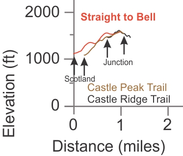
Straight to Bell Trail
T3.5
![]()
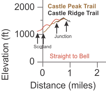
Description This is another steep route to get to Castle Peak from Scotland. The elevation profile below compares the steepness of this trail with that of the Castle Peak Trail. Both are pretty steep. Whereas the Castle Ridge Trail runs along a rocky ridge overlooking El Escorpion, Straight to Bell runs along a more northern ridge that overlooks Bell Canyon, and this trail has a much smoother tread.
Technical Rating T3.5
![]()
|
Length (miles) |
1.0 |
|
Climb (feet) |
450 (From Scotland to Castle Peak Trail) |
|
Descent (feet) |
50 |
Trail Profile Back to the Top
 Switzerland
T3
Switzerland
T3
![]()
Description This steep singletrack trail runs from North Ridge Trail at the top down to the E. LV Canyon Trail. It is mostly firm but some sections have loose rocks. It's super fun to blast down on a mountain bike. Like most of the trails in theis area, it will be overgrown with weeds in the spring, mostly mustard.
Watch this video, starting at 1:34 to see Switzerland from the top.
Technical Rating T3.5
![]()
|
Length (miles) |
1.1 |
|
Climb (feet) |
20 (From North Ridge Trail to E. LV Canyon Trail) |
|
Descent (feet) |
660 |
Trail Profile Back to the Top
Description Sorry, it's been a long time since I was on this trail. I'll have to revisit it before I can write up the desciption. A lot of it wasn't in good shape the last time I was there and it might be completely obliterated now.
Technical Rating
|
Length (miles) |
0.75 |
|
Climb (feet) |
600 |
|
Descent (feet) |
60 |
This trail is too short to provide an elevation profile. Back to the Top
Upper England T2
![]()
 Description This singletrack
trail connects England to Ireland
and may provide the least difficult route to ride up to North
Ridge Trail from E. LV Canyon Trail. Although
the difference in elevation from one end to the other is only 55', the amount
of climbing involved is a lttle more than three times that, so you know it has
a number of hills! But either direction is fun for a strong rider who doesn't
mind climbing the hills.
Description This singletrack
trail connects England to Ireland
and may provide the least difficult route to ride up to North
Ridge Trail from E. LV Canyon Trail. Although
the difference in elevation from one end to the other is only 55', the amount
of climbing involved is a lttle more than three times that, so you know it has
a number of hills! But either direction is fun for a strong rider who doesn't
mind climbing the hills.
Watch this video, starting at 0:44 to see some of Upper England.
Technical Rating T2
![]()
|
Length (miles) |
0.56 |
|
Climb (feet) |
120 (From Ireland to England) |
|
Descent (feet) |
180 |
Trail Profile Back to
the Top
It's hard to tell from this profile, but Upper England connects England
and Ireland. It does not cross Scotland
Upper Las Virgenes Canyon Trail
(aka
East Las Virgenes Canyon Trail; Bell Canyon Trail)
Description This is a continuation of the Las Virgenes Canyon Trail and it is described with the Las Virgenes Canyon Trail.
The trails in the wedge-shaped area between Ahmanson Ranch House Road, East Las Virgenes Canyon Trail and Crazy Snake are all "social" trails, that is, not officially sanctioned. They get a lot of use nevertheless. They are all singltracks with a generally firm tread. Most are pretty steep heading straight down the hillside for at least part of their length. The exception is Strollin', and to a lesser degree, Up and Over. Expect all of them to become overgrown with grass in the spring.
JJ's Jamboree T2.5
![]()
This trail is 0.42 miles long and drops 200' from Ahmanson Ranch House Trail to E. LV Cyn Trail, and climbs 10'.
 Pathway
T2.5
Pathway
T2.5
![]()
This trail has a moderate grade except for one short, very steep climb off-camber near the bottom. It is 0.17 miles long, dropping 124' from Ahmanson Ranch House Trail to E. LV Cyn Trail, and climbs 10'.
Shakedown T4
![]()
This trail leads from the Mary Wiesbrock Loop to Crazy Snake. It is very steep near the bottom where it joins Crazy Snake, and is a little loose and powdery with some small drops. The T4 rating is because of the steepness at the bottom. It is 0.24 miles long, dropping 115' and climbing 20' at the top.
Splitz T3.5
![]()
This is a very steep singletrack that climbs straight up the hill from Strollin' to Up and Over. It is 0.16 miles long, drops 150' and climbs zero feet.
Strollin' T2
![]()
This very pleasant rolling trail runs from about a third of the way down Crazy Snake to Pathway. Over 0.63 miles,it climbs and drops a few time, with an accumulate climbing of about 120' with the start and end being at the same elevation. It can be overgrown with grass in the spring, but not mustard.
 Tourist TrapT3
![]()
This is a fun short singletrack for experienced mountain bikers that drops from Ahmanson Ranch House Trail to E. LV Cyn Trail. It is broad and steep, 0.24 miles long with 135' of descent and 15' climbing. Watch this video, starting at 13:39, to see some of this trail.
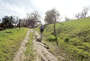
 Up and Over
T2.5
Up and Over
T2.5
![]()
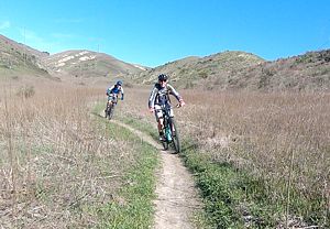
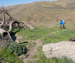
This is a mostly smooth rolling singletrack with firm tread that runs from Mary Wiesbrock Loop to Ahmanson Ranch House Trail, but downhill to Ahmanson Ranch House Trail is steeper and has some big ruts as seen in the photo to the left. It is 0.43 miles long with 80' of climbing from MW Loop heading northeast, and 100' of descent.
Watch this video, starting at 12:30 to see some of this trail.
This page was last updated March 19, 2023.
|
|
Thanks for looking at Steve's guide to trails in Ventura County, the Santa Monica Mountains National Recreation Area (SMMNRA) and other locations. |
|