Trails of
Old Topanga

On
the Topanga Ridge Trail with Stunt Road visible in the background
down below.
|
Trails of Old Topanga |
||
|
||
This area is dominated by Saddle Peak at the south-west and Calabasas Peak in the west. Probably the most prominent trail is the shaded, fragrent and quiet Hondo Canyon segment of the Backbone Trail, but the one with the best views is Calabasas Peak Motorway. An offshoot of Calabasas Peak Mtwy is Red Rock Road that leads down into Red Rock Canyon. You can tell from the name that it will be pretty! The most spectacular trail is on Topanga Ridge where you hike, scramble and climb along the knife edge of the ridge.
This map includes the Stunt High and Cold Creek Canyon Trails that are shown on the next map to the west, Monte Nido and Calabasas South, because these trails can be used to make loop routes with the Topanga Ridge trails. Also, that map extends the Backbone Trail down to Malibu Canyon Road and the eastern edge of Malibu Canyon State Park. The Backbone Trail continues to the east on the Trippet Ranch Map.
|
|

Trailheads, Parking and Features
a. Calabasas Peak and Cold Creek Trail parking on the shoulder of
Stunt Road, 1 mile south-east of Mulholland highway. Map
and Directions.
b. The Lois Ewan Overlook at the top of Stunt
Road where it becomes Saddle Peak Road. Map
and Directions.
c. At the side of Saddle Peak Road. There is a
short connector to get to the Backbone Trail.
Map
and Directions.
d. At the side of Old Topanga Canyon Road.
Map
and Directions.
e. At the side of Greenleaf Canyon Road.
Map
and Directions.
f. Parking in the Dead Horse Trail lot in
Topanga State Park. There is a fee to park here. Often this lot is closed.
Map
and Directions.
g. On the shoulder of Stunt Road at or near where
a trail emerges.
h. Cold Creek Trail west end at McKain Road. Map
and Directions.
i. At the side of Mulholland Highway.
Map
and Directions.
j. Off of Old Topanga Road. Turn south-west onto Calabasas
Peak Mtwy and bear left. There is a small dirt lot just before the gate. Map
and Directions.
k. There are a few spots at the side of Summit-to-Summit
Mtwy next to Topanga Canyon Blvd. Map
and Directions.
l. At the Top of Topanga Overlook. Turn north-west from
Topanga Canyon Blvd and park at the end of the short driveway. Map
and Directions.
m. Fee parking at the west end of Red Rock Road. Access
is from Old Topanga Canyon Road.
Map
and Directions.
n. Fee parking for Ed Edelman Park. Be very careful entering
and exiting this parking area because it's on a blind curve. Map
and Directions.
y. Foundation for an old tower, completely covered with
graffiti. The colors and designs change regularly!
z. Locked gates. The Cold Creek Canyon Trail is
closed to the public and there is no access.
Download the GPS tracks ![]() to help you find your way. This GPX file contains tracks for all the trails
in this area.
to help you find your way. This GPX file contains tracks for all the trails
in this area.
[1,2,3,4] Backbone Trail - [1]Fossil Ridge Trail, [2]Hondo Canyon Trail, [3]Henry Ridge Trail and [3a]Dead Horse Trail
Description The Backbone Trail between the top of Stunt Road and the Dead Horse Trail segment on the east side of Topanga Canyon Blvd encompasses three trail segments that total 4.8 miles, 440' of climbing (travelling west to east) and 2020' of descent. Probably the most popular hike is to start on Old Topanga Canyon Rd and hike up to the Lois Ewan Overlook at the top of Stunt Rd and back, or the other way around. This can also be done as a shuttle hike, but it's a very long drive up Saddle Peak Road.
 Travelling
west to east and generally downhill...
Travelling
west to east and generally downhill...
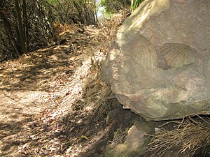
Fossil Ridge Trail T2
![]() starts from Topanga Ridge Motorway about 400' from the Lois Ewan Overlook with
a short but steep climb. After that, the slope is mostly gentle. The western
half mile is quite shaded by tall chaparral; after that it opens up. The trail
gets its name from fossils that can be seen in the rocks next to the trail.
It ends at the top of the Hondo Canyon Trail, and there is a short spur that
leads to Saddle Peak Rd.
starts from Topanga Ridge Motorway about 400' from the Lois Ewan Overlook with
a short but steep climb. After that, the slope is mostly gentle. The western
half mile is quite shaded by tall chaparral; after that it opens up. The trail
gets its name from fossils that can be seen in the rocks next to the trail.
It ends at the top of the Hondo Canyon Trail, and there is a short spur that
leads to Saddle Peak Rd.
 Hondo
Canyon Trail screams solitude when you hike through because it is very quiet
(no traffic noise) and shaded by oaks, sycamores and tall chaparral, especially
bay trees. The bay leaves on the trail provide a wonderful fragrance and a soft,
noise-deadening step. Being on the north face of the ridge means even
more shade. On the other hand, this is a popular trail so you can expect to
pass others on your way; the bottom part of the trail traverses a large meadow. This
trail has lots of climbing/descent and switchbacks, some steps, and some
of it is rugged. The technical rating is mostly T2
Hondo
Canyon Trail screams solitude when you hike through because it is very quiet
(no traffic noise) and shaded by oaks, sycamores and tall chaparral, especially
bay trees. The bay leaves on the trail provide a wonderful fragrance and a soft,
noise-deadening step. Being on the north face of the ridge means even
more shade. On the other hand, this is a popular trail so you can expect to
pass others on your way; the bottom part of the trail traverses a large meadow. This
trail has lots of climbing/descent and switchbacks, some steps, and some
of it is rugged. The technical rating is mostly T2
![]() to T3
to T3
![]() but some parts are T4.5
but some parts are T4.5 ![]() .
Watch for poison oak at the edge of the trail in places, but it's easy to avoid.
If it has rained recently, stay off this trail because it takes a long time
to dry and is very slippery when wet.
.
Watch for poison oak at the edge of the trail in places, but it's easy to avoid.
If it has rained recently, stay off this trail because it takes a long time
to dry and is very slippery when wet.
Henry Ridge Trail connects the bottom of the Hondo Canyon
Trail and the bottom of the Dead Horse Trail. For such a short trail (0.7 miles)
it has a surprising amount of climbing! From Old Topanga Canyon Rd, it starts
up a moderately steep but firm and rocky singletrack trail T3.5
![]() then turns up a steep motorway T1.5
then turns up a steep motorway T1.5
![]() ,
then continues east on another fairly steep singletrack with some steps T2.5
,
then continues east on another fairly steep singletrack with some steps T2.5
![]() .
This last section is very pretty and shaded by oak trees, but watch for poison
oak on the edge of the trail. The trail ends at the east on Greenleaf Canyon
Road about 200' from Topanga Cyn Blvd. The BBT continues on the Dead
Horse Trail about 50' north of Greenleaf Cyn Rd on the east side of Topanga
Cyn Blvd. There are some forks in the trail on Henry Ridge so it may take a
little exploring to find your way through, but a decent sense of direction will
get you through. If you're going from west to east, just watch out for the trail
that forks off of Henry Ridge Motorway to the east. You don't have to go very
far up this dirt road before you get to the trail.
.
This last section is very pretty and shaded by oak trees, but watch for poison
oak on the edge of the trail. The trail ends at the east on Greenleaf Canyon
Road about 200' from Topanga Cyn Blvd. The BBT continues on the Dead
Horse Trail about 50' north of Greenleaf Cyn Rd on the east side of Topanga
Cyn Blvd. There are some forks in the trail on Henry Ridge so it may take a
little exploring to find your way through, but a decent sense of direction will
get you through. If you're going from west to east, just watch out for the trail
that forks off of Henry Ridge Motorway to the east. You don't have to go very
far up this dirt road before you get to the trail.
|
Length (miles) |
Fossil Ridge: 0.6, Hondo Canyon: 3.5, Henry Ridge: 0.7 |
|
Climb (feet) |
Fossil Ridge: 70, Hondo Canyon: 100, Henry Ridge: 270 (West to east) |
|
Descent (feet) |
Fossil Ridge: 110, Hondo Canyon: 1650, Henry Ridge: 260 |
Trail Profile Back to the Top

[4] Backbone
Trail - Saddle Peak Trail T2
![]() to T5
to T5
![]() ,
NB
,
NB
![]()
Description The Saddle Peak trail continues west from the Lois Ewan Overlook at the top of Stunt Rd, connecting to the Piuma Ridge Trail in 5 miles when the BBT crosses Piuma Road. More importantly for this map, it connects to the Stunt High Trail in 1.9 miles from Lois Ewan Overlook, and the Stunt High Trail can be taken down to Cold Creek Trail and the base of Calabasas Peak Motorway to make a beautiful, but strenuous, loop hike with the Topanga Ridge Trail. The Saddle Peak Trail is described on the Calabasas South web page.
Technical Rating T2
![]() to T5
to T5
![]() ,
NB
,
NB
![]()
[5] Cold Creek Trail T1.5
![]() ,
T4
,
T4
![]() ,
NB
,
NB
![]()
 Description This trail leads from a large parking area
on Stunt Road, through the Meadow Loop to McKain Rd. It's most used to get to
the bottom of the Stunt High Trail, a very popular climb. From Stunt Rd to the
bottom of the Stunt High Trail, Cold Creek Trail is very broad, firm and even
T1.5
Description This trail leads from a large parking area
on Stunt Road, through the Meadow Loop to McKain Rd. It's most used to get to
the bottom of the Stunt High Trail, a very popular climb. From Stunt Rd to the
bottom of the Stunt High Trail, Cold Creek Trail is very broad, firm and even
T1.5
![]() .
There is lots of shade under a canopy of huge oaks, and it runs alongside the
perennial Cold Creek. Humboldt lilies have been spotted growing on the banks
of the creek here! Beyond the bottom of the Stunt High Trail, Cold Creek Trail
is no longer tree-shaded and becomes very rocky and rutted in places T4
.
There is lots of shade under a canopy of huge oaks, and it runs alongside the
perennial Cold Creek. Humboldt lilies have been spotted growing on the banks
of the creek here! Beyond the bottom of the Stunt High Trail, Cold Creek Trail
is no longer tree-shaded and becomes very rocky and rutted in places T4
![]() .
.
Technical Rating T1.5
![]() ,
T4
,
T4
![]() ,
NB
,
NB
![]()
|
Length (miles) |
0.6 to Lower Stunt High Trail; 1.1 total |
|
Climb (feet) |
Zero to Lower Stunt High Trail; 20 total |
|
Descent (feet) |
150' to Lower Stunt High Trail; 270 total |
Trail Profile Back to the Top

[6] Lower Stunt High Trail,
[7]Upper Stunt High Trail, [8]Stunt Rd to Backbone Connector T2.5
![]() ,
NB
,
NB
![]()
 Description As you can see from the map, the very popular
Stunt High Trail consists of three segments - Lower, Upper and Connector to
the Backbone Trail. The trail climbs from the Cold Creek Trail to the Backbone
Trail, but many people continue up the BBT to the top or all the way to
the Lois Ewan Overlook at Saddle Peak Road. (If you do continue up on the BBT,
make sure not to miss the turn onto the Stunt High Trail on the way back down!) The
trail is largely shaded with high chaparral, and it faces north so you are further
protected from the sun. As you climb, the view of Calabasas Peak and Topanga
Ridge just gets better and better. The trail crosses Stunt Road twice and the
road delineates the various trail sections. When climbing the trail, it continues
about 200' to the west from where the lower segment emerges onto the road.
Description As you can see from the map, the very popular
Stunt High Trail consists of three segments - Lower, Upper and Connector to
the Backbone Trail. The trail climbs from the Cold Creek Trail to the Backbone
Trail, but many people continue up the BBT to the top or all the way to
the Lois Ewan Overlook at Saddle Peak Road. (If you do continue up on the BBT,
make sure not to miss the turn onto the Stunt High Trail on the way back down!) The
trail is largely shaded with high chaparral, and it faces north so you are further
protected from the sun. As you climb, the view of Calabasas Peak and Topanga
Ridge just gets better and better. The trail crosses Stunt Road twice and the
road delineates the various trail sections. When climbing the trail, it continues
about 200' to the west from where the lower segment emerges onto the road.
Stunt High Trail is a moderate steepness with mostly a firm tread but has some rutted and rocky sections.
|
Length (miles) |
1.9 total; 0.8 to the first crossing of Stunt Rd; 1.7 to the second Stunt Rd Crossing |
|
Climb (feet) |
880 total (to the BBT - Saddle Peak Trail) |
|
Descent (feet) |
Zero total |
Trail Profile Back to the Top
The Stunt High Trail elevation profile is shown with that of Cold Creek Trail above.
[9] Cold Creek High Trail T4
![]() ,
NB
,
NB
![]()
Description The Cold Creek High Trail descends from Stunt Road to Cold Creek Canyon over 1.75 miles. It is described on the Calabasas South and Monte Nido web page.
 [10] Meadow Loop - Meadow
Trail, Yucca Trail and Deer Grass Trail (AKA Cold Creek Valley Preserve) T2
[10] Meadow Loop - Meadow
Trail, Yucca Trail and Deer Grass Trail (AKA Cold Creek Valley Preserve) T2
![]() NB
NB
![]()
Description This 0.7 mile trail loops around an area covered by grass and chaparral that has beautiful views of the surrounding mountains. There are some small hills, but overall there's not a lot of climbing. The loop is made up of three trails: the southwest segment is part of the Cold Creek Trail, the Meadow Trail makes up the western section, the northern section is the Deer Grass Trail and finally the south-east segment is the Yucca Trail. Whew! There are some short spurs that lead to Stunt or McKain Road with nearby parking.
 [11] Cold Creek Canyon Trail T2.5
![]() ,
HO
,
HO
![]()
Description This trail is closed to the public as of April 2012. It runs through the Cold Creek Canyon Preserve, an area being maintained by Mountains Restoration Trust (MRT), and has been closed to prevent infestation by New Zealand mudsnails, a serious problem in the Santa Monica Mountains and elsewhere. The tiny snails can travel from stream to stream on the boots of hikers. Until a way can be found to keep hikers and their boots out of the streams, this trail will remain closed.
It's a real shame the trail is closed because it's really pretty. When it does open again, you need a free permit to use it, and unless you're a member of MRT, you need to start at the top and turn around at the bottom and hike back up. That's because the gate at the bottom is locked, but MRT members are given the combination so they can get out. You can get a permit by phoning the MRT. The trail is well maintained and is well shaded by tall chaparral. It crosses Cold Creek at least twice, which is why there's such a concern about the NZ mudsnails. Along the way you'll see some old vehicles and the remains of an old hermit dwelling, built of sandstone. The steeper sections of the trail have steps on them.
|
Length (miles) |
1.7 |
|
Climb (feet) |
150 |
|
Descent (feet) |
1050 |
Trail Profile Back to the Top

[12] Calabasas
Peak Motorway T2
![]() and [13]Summit to Summit Motorway T1
and [13]Summit to Summit Motorway T1
![]()
 Description The Calabasas
Peak Motorway is tremendous for views and exercise! Starting at Stunt Road,
the view is to the south of the very rocky Saddle Peak and to the west over
Calabasas South to Ladyface Mtn. As you climb, the road traverses some amazing
rock 'ribs' before crossing to the east side of Calabasas Peak where the
views turn to Old Topanga. After about 2.5 miles, the road bends east and
the view overlooks both Old Topanga and the San Fernando Valley around the Warner
Center. Calabasas Peak Mtwy ends at Old Topanga Canyon Road and picks up again
on the other side as Summit to Summit Motorway. (Be very careful crossing the
road, especially when heading east, because you're on a blind curve and can't
see cars speeding towards you until they're very close!)
Description The Calabasas
Peak Motorway is tremendous for views and exercise! Starting at Stunt Road,
the view is to the south of the very rocky Saddle Peak and to the west over
Calabasas South to Ladyface Mtn. As you climb, the road traverses some amazing
rock 'ribs' before crossing to the east side of Calabasas Peak where the
views turn to Old Topanga. After about 2.5 miles, the road bends east and
the view overlooks both Old Topanga and the San Fernando Valley around the Warner
Center. Calabasas Peak Mtwy ends at Old Topanga Canyon Road and picks up again
on the other side as Summit to Summit Motorway. (Be very careful crossing the
road, especially when heading east, because you're on a blind curve and can't
see cars speeding towards you until they're very close!)
 Summit
to Summit Motorway continues east and then north-east from Old Topanga Canyon
Rd and ends at Topanga Canyon Blvd. The views here are again north into the
San Fernando Valley and south into Old Topanga. There is one spot where you
can get tripped up on this route where the road is paved where it enters a small
neighborhood and there is a paved cross street. When travelling east, turn left
to continue (not straight as you might expect). When travelling south-west,
turn right at this intersection.
Summit
to Summit Motorway continues east and then north-east from Old Topanga Canyon
Rd and ends at Topanga Canyon Blvd. The views here are again north into the
San Fernando Valley and south into Old Topanga. There is one spot where you
can get tripped up on this route where the road is paved where it enters a small
neighborhood and there is a paved cross street. When travelling east, turn left
to continue (not straight as you might expect). When travelling south-west,
turn right at this intersection.
You cross Topanga Cyn Blvd to get to the Top of Topanga Overlook, but the warning about crossing the Old Topanga Cyn Rd goes double here - there are many more cars and they go much faster! (The photo to the left shows the view of the east side of Calabasas Peak from Summit to Summit, looking over Old Topanga.)
Calabasas Peak Mtwy has mostly long, moderately
steep climbs with some short sections that are even steeper. This will test
mountain bikers' stamina! Some of the steeper sections are rutted and uneven
which is why it gets a T2
![]() rating, but most of it is T1. Summit to Summit Mtwy has much less climbing
overall, but still there are some relatively short and moderately steep climbs.
rating, but most of it is T1. Summit to Summit Mtwy has much less climbing
overall, but still there are some relatively short and moderately steep climbs.
A popular hike is up Calabasas Peak Mtwy and down Red Rock Road into Red Rock Canyon, possibly includind a hike up Red Rock Trail. This is an out-and-back hike. A spectacular hike is up Calabasas Peak Mtwy and then up Topanga Ridge Trail, but this is much more difficult and only for strong hikers.
|
Length (miles) |
Calabasas Pk Mtwy: 3.6, Summit to Summit Mtwy: 3.1 |
|
Climb (feet) |
Calabasas Pk Mtwy: 1000, Summit to Summit Mtwy: 550 (south-west to north-east) |
|
Descent (feet) |
Calabasas Pk Mtwy: 700, Summit to Summit Mtwy: 570 |
Trail Profile Back to the Top

[14] Red Rock Road T1
![]()
 Description The Red
Rock Road in Red Rock Canyon leads downhill 1.1 miles on dirt from Calabasas
Peak Motorway to the start of the paved section. There is pay parking here.
The paved section continues with a very gentle grade 0.9 miles to Old Topanga
Canyon Rd. The dirt section gets increasingly steep as you get closer to Calabasas
Peak Mtwy.
Description The Red
Rock Road in Red Rock Canyon leads downhill 1.1 miles on dirt from Calabasas
Peak Motorway to the start of the paved section. There is pay parking here.
The paved section continues with a very gentle grade 0.9 miles to Old Topanga
Canyon Rd. The dirt section gets increasingly steep as you get closer to Calabasas
Peak Mtwy.
Red Rock Canyon has some beautiful pinkish rock formations and the paved road goes through a rustic old neighborhood. Once on Red Rock Road, a popular hike is to head north and up on Red Rock Trail.
Technical Rating T1
![]()
|
Length (miles) |
Dirt: 1.1, Paved: 0.9, Total: 2.0 |
|
Climb (feet) |
zero |
|
Descent (feet) |
Dirt: 430, Paved: 100, Total: 530 |
Trail Profile Back to the Top

[15] Red Rock Trail T4
![]()
 Description This
is a well-worn but apparently unmaintained trail the climbs to a ridge 360'
above Red Rock Road, but still far short of the elevation of Calabasas Peak
Mtwy. This is a pretty trail, a little gnarly and rutted but the views from
the top are worth the climb. From the top, at least two unsanctioned trails
continue - one westerly along the ridge top (shown on the map), and one north
down the ridge towards Zuniga Rd (not shown on the map).
Description This
is a well-worn but apparently unmaintained trail the climbs to a ridge 360'
above Red Rock Road, but still far short of the elevation of Calabasas Peak
Mtwy. This is a pretty trail, a little gnarly and rutted but the views from
the top are worth the climb. From the top, at least two unsanctioned trails
continue - one westerly along the ridge top (shown on the map), and one north
down the ridge towards Zuniga Rd (not shown on the map).
Technical Rating T4
![]()
|
Length (miles) |
0.8 |
|
Climb (feet) |
380 |
|
Descent (feet) |
20 |
The Red Rock Trail elevation profile is shown above with that for Red Rock Road.
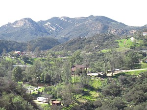
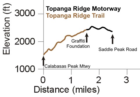
[16] Topanga Ridge
Motorway T2
![]() and [16a]Topanga Ridge Trail T5
and [16a]Topanga Ridge Trail T5
![]()
 Description The route
along Topanga Ridge provides some fantastic views of Saddle Peak, Calabasas
Peak and its motorway, and, on the Trail at least, of the rocky knife edge of
Topanga Ridge. The banner photo at the top of this page shows
the view towards Saddle Peak from the Trail. The photo to the right shows a
bit of Calabasas Peak Motorway and a meadow near the bottom that the trail crosses.
About a mile from the bottom, the trail turns into a nice singletrack, and another
half mile along, into a motorway. Lots of people take the Trail up the ridge
so it's pretty easy to follow, but it can be a bit overgrown in some spots so
a little exploring to find the way could be in order. The surface is mostly solid
rock that require a little scrambling and finding handholds but there are some
loose and steep sections, but they're not very long.
Description The route
along Topanga Ridge provides some fantastic views of Saddle Peak, Calabasas
Peak and its motorway, and, on the Trail at least, of the rocky knife edge of
Topanga Ridge. The banner photo at the top of this page shows
the view towards Saddle Peak from the Trail. The photo to the right shows a
bit of Calabasas Peak Motorway and a meadow near the bottom that the trail crosses.
About a mile from the bottom, the trail turns into a nice singletrack, and another
half mile along, into a motorway. Lots of people take the Trail up the ridge
so it's pretty easy to follow, but it can be a bit overgrown in some spots so
a little exploring to find the way could be in order. The surface is mostly solid
rock that require a little scrambling and finding handholds but there are some
loose and steep sections, but they're not very long.
At the north end of the motorway is an old foundation for some
structure that is no longer with us. The paint on the foundation is updated
regularly by graffitiists so it's always worth stopping here to look at the
artwork and have a snack. From there it's about a mile to Saddle Peak Road and
the Lois Ewan Overlook. The road is a little rocky and rutted so it gets a terrain
rating of T2
![]() .
There's lots of width to go around the rocks and ruts.
.
There's lots of width to go around the rocks and ruts.
Not far south of the painted foundation is a single tree that grows on the top of the ridge. This tree can be seen from miles away and so marks the location of Topanga Ridge.
A great loop hike starts at the Calabasas Peak Mtwy trailhead on Stunt Road, climbs Calabasas Peak Mtwy to the bottom of Topanga Ridge Trail, climbs Topanga Ridge to Saddle Peak Rd, heads west on Saddle Peak Trail, descends Stunt High Trail and completes the loop on Cold Creek Trail. The total distance is about 7.6 miles with roughly 2000' of climbing. There are great views on the way up and down, but this isn't for novice hikers!
|
Length (miles) |
2.5 |
|
Climb (feet) |
1250 |
|
Descent (feet) |
420 |
Trail Profile Back to the Top
[17] Secret Trail (AKA Calabasas-Cold
Creek Trail) T2.5
![]()
 Description This
popular and well-used trail winds it's way up to Calabasas Peak Mtwy from Mulholland
Highway, where there is room for a few cars to park at the side of the
road. The tread is firm and generally fairly smooth but there are a few rocky
spots, and some steps. There isn't much shade, but there can be tall mustard
in the spring.
Description This
popular and well-used trail winds it's way up to Calabasas Peak Mtwy from Mulholland
Highway, where there is room for a few cars to park at the side of the
road. The tread is firm and generally fairly smooth but there are a few rocky
spots, and some steps. There isn't much shade, but there can be tall mustard
in the spring.
Technical Rating T2.5
![]()
|
Length (miles) |
1.4 |
|
Climb (feet) |
600 |
|
Descent (feet) |
200 |
Trail Profile Back to the Top

[18] Calabasas Highlands Trail
Description This trail climbs from the community of Calabasas Highlands to Calabasas Peak Mtwy. The lower half of the trail has several forks, and not all are shown on the map at the top of this page. In fact, looking at the satellite images, two of the previous access points now have houses or construction on them. It looks like the best access is up a gap between the houses at 23660-23678 Summit Drive (addresses courtesy of Google Maps). Depending on the route you take, you can expect it to be about 1 mile long with 400' or more of climbing.
Description The full name of this park is "Summit Valley Edmund D. Edelman Park." Here is a link to the official website. There are several trails there but I haven't mapped them out completely. Eventually this area will have a web page of it's own.
This page was last updated February 22, 2017
|
|
Thanks for looking at Steve's guide to trails in Ventura County, the Santa Monica Mountains National Recreation Area (SMMNRA) and other locations. |
|