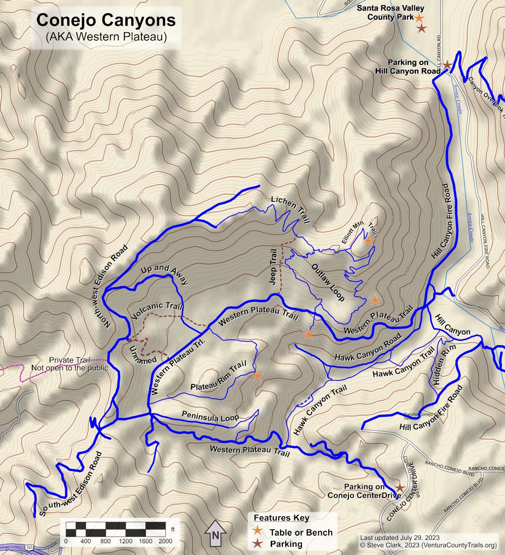
Trails of
Conejo Canyons
Open
Space area Trails
(AKA Western Plateau)
- Official Website
- Suggested Rides and Hikes
- Geocaches
The
Western Plateau section of Conejo Canyons
|
Trails of Conejo Canyons
Open
Space area Trails |
||
|
||
|
||
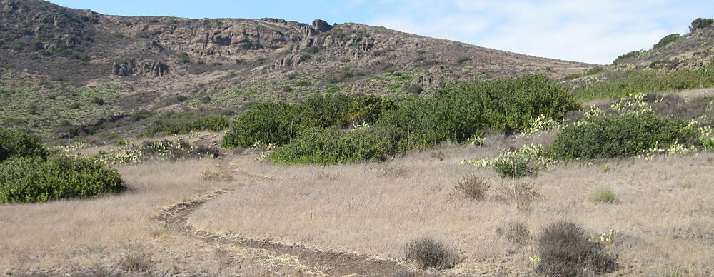
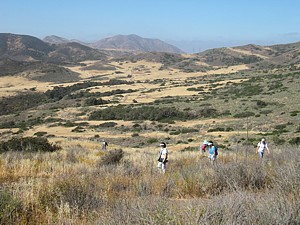
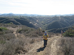
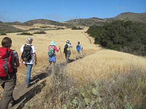
This large open space area lies immediately west of Wildwood Park. You may find many minor trails made by equestrians, particularly in the meadows, that aren't shown on this map. Those trails tend to appear and disappear as routes are used or not.
Despite its proximity to Wildwood Park, access between the two is limited because the Arroyo Conejo separates them, and the public is not allowed on the paved Hill Canyon Road that runs along Arroyo Conejo. But Conejo Open Space Conservation Agency (COSCA) is working towards getting a bridge installed that will allow more direct access. However, if you live in the Santa Rosa Valley, access is easy because of the bridge that crosses the arroyo and nearby parking in Santa Rosa County Park. There are also two trailheads with roadside parking in the Newbury Park neighborhood of Thousand Oaks.
The weather will play an important part of how much you enjoy your visit here. It's very hot in the summertime, so early morning adventures are best then. The dirt becomes very mucky and sticky after it rains, so you'll want to wait at least a week after significant rainfall before coming here. Otherwise you'll be scraping mud off your shoes or tires for a long time, not to mention the damage to the trails that will be done by tracks, footprints and especially hoofprints.
|
|
Trails are listed here in alphabetic order. Download the GPS tracks ![]() to help you find your way. This GPX file contains tracks for all the trails
in this area.
to help you find your way. This GPX file contains tracks for all the trails
in this area.
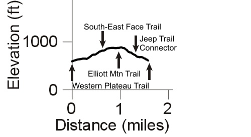
Elliot Mountain Trail T2
![]()
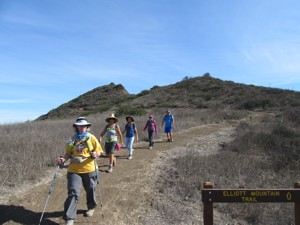 Description This short
spur leads from the highest section of the Outlaw Loop up to an overlook
and bench near the top of Elliott Mountain. In early 2015, COSCA named this
peak for Burt Elliott, a seemily tireless open space advocate and
volunteer who plied the trails while hiking, running or riding his mountain
bike. He was a major force in helping to organize the Spring and Annual Conejo
Trailwork Days, and could be found helping build and restore trails somewhere
in the Santa Monica Mountains on most Saturdays. Burt passed away in early 2014
and this peak is a tribute to him.
Description This short
spur leads from the highest section of the Outlaw Loop up to an overlook
and bench near the top of Elliott Mountain. In early 2015, COSCA named this
peak for Burt Elliott, a seemily tireless open space advocate and
volunteer who plied the trails while hiking, running or riding his mountain
bike. He was a major force in helping to organize the Spring and Annual Conejo
Trailwork Days, and could be found helping build and restore trails somewhere
in the Santa Monica Mountains on most Saturdays. Burt passed away in early 2014
and this peak is a tribute to him.
The trail has a gentle climb all the way up, interupted by one nasty steep switchback.
Technical Rating T2
![]()
|
Length (miles) |
0.2 |
|
Climb (feet) |
100 |
|
Descent (feet) |
zero |
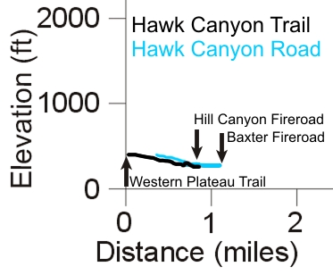
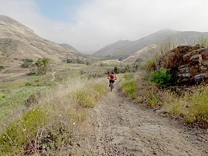
Hawk Canyon Trail T2
![]()
Hawk
Canyon Road T2
![]()
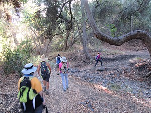 Description This pair
of very gently sloping trails, as you might expect from the names, run along
Hawk Canyon, one on each side of the stream that runs through it. The Trail
connects at its south end to the Western
Plateau Trail, and merges with the Road at its north end in two places. It's mostly shady
under a canopy of trees. Watch for growth at the side of the trail; there's
lots of poison oak here!
Description This pair
of very gently sloping trails, as you might expect from the names, run along
Hawk Canyon, one on each side of the stream that runs through it. The Trail
connects at its south end to the Western
Plateau Trail, and merges with the Road at its north end in two places. It's mostly shady
under a canopy of trees. Watch for growth at the side of the trail; there's
lots of poison oak here!
The Road is a little higher up and mostly traverses grasslands, passing a few old oak trees. It ends in a box canyon at the south-west, ending at Hill Canyon Fireroad and the Western Plateau Trail as it curves north.
During the 2012 COSCA Annual Trailwork Day, the Hawk Canyon Trail was extended north-east from the creek crossing to where it now joins the Road. Also, a bypass was built around a short section that is very narrow and is being undercut by the creek. One day it will disappear altogether.
In October 2016 during the Conejo Open Space Trailwork Day, the trail was further extended 1400' north-east to meet the Hawk Canyon Road about 110 yards from the bottom of the Hidden Rim Trail that was built at the same time.
Technical Rating T2
![]()
|
Length (miles) |
0.85 (trail); 0.63 (road) |
|
Climb (feet) |
160 (trail, north-east to south-west); 100 (road, east to west) |
|
Descent (feet) |
65; 60 |
Trail Profile Back to the Top
 Hidden Rim Trail (Previously Baxter Singletrack)
T2.5
Hidden Rim Trail (Previously Baxter Singletrack)
T2.5
Description The Hidden Rim Trail was built in October 2016, during the Conejo Open Space Trailwork Day. It starts almost half way down the Hill Canyon Fire Road from Rancho Conejo Blvd at the large white gate. Watch carefully for it! It is longer than the remainder of the fireroad, and is about 10% less steep. It gets a slightly higher technical rating compared to most singletracks because it is still pretty steep in a few spots. For mountain bikers, it's a tough climb up!
Technical Rating T2.5
![]() (singletrack)
(singletrack)
|
Length (miles) |
0.33 (singletrack) |
|
Climb (feet) |
0 |
|
Descent (feet) |
260 |
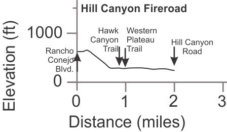
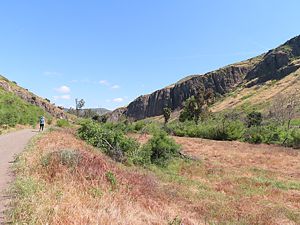 Hill
Canyon Fireroad T1
Hill
Canyon Fireroad T1
![]()
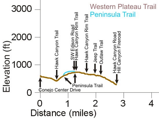
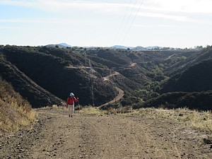
Description This fire road provides access to the area from the Santa Rosa Valley and Hill Canyon, and is one of two access points from Newbury Park. It runs mainly north-south. The southern-most section is quite steep downhill and used to known as the "Baxter Fireroad," after the pharmaceutical company that used to be situated next to it. In contrast, the remaining 1.3 miles of the road is pretty flat, dropping only 50' from the bottom of Baxter FR to the bridge at the north end. It runs along parallel to Arroyo Conejo creek.
There is a major junction where this road, the Western Plateau Trail and Hawk Canyon Road all come together, with Hawk Canyon Trail nearby too. From that junction, you'll gain elevation on the Western Plateau Trail and will get to some great views. On the other hand, the Hawk Canyon trails lead along a creek under a shady tree canopy.
Technical Rating T1
![]()
|
Length (miles) |
2.0 |
|
Climb (feet) |
100 (Travelling south to north) |
|
Descent (feet) |
480 |
Trail Profile Back to the Top
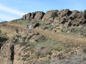
Jeep Trail (AKA Straight
Shooter) T3
![]()
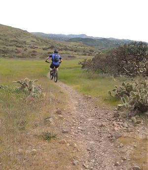
Description In the past, the Western Plateau was plagued by jeeps and other OHVs that illegally drove the trails here and tore up new paths up the hillsides. This enduring trail is a steepish, rocky legacy of that era.
Technical Rating T3
![]()
|
Length (miles) |
0.28 |
|
Climb (feet) |
225 |
|
Descent (feet) |
zero |
Lichen Trail T3
 Description As
of early 2016, this is the newest trail in the Western Plateau, and in all of
Thousand Oaks for that matter. It was built in September 2015 and joins
the Outlaw Loop to the very top of the North-West Edison Road, thus enabling
a loop route with lots of climbing. It switchbacks up a very steep slope, and
as you might notice from the photo at right, at least some of it is not for
people who don't like exposure to steep drops! It is not as wide as typical
COSCA singletracks, so with that and the exposure, it is rated a little more
difficult than usual for a singletrack. It also has some very rough sections
over exposed volcanic rock.
Description As
of early 2016, this is the newest trail in the Western Plateau, and in all of
Thousand Oaks for that matter. It was built in September 2015 and joins
the Outlaw Loop to the very top of the North-West Edison Road, thus enabling
a loop route with lots of climbing. It switchbacks up a very steep slope, and
as you might notice from the photo at right, at least some of it is not for
people who don't like exposure to steep drops! It is not as wide as typical
COSCA singletracks, so with that and the exposure, it is rated a little more
difficult than usual for a singletrack. It also has some very rough sections
over exposed volcanic rock.
Technical Rating T3
![]() (due narrowness and exposure)
(due narrowness and exposure)
|
Length (miles) |
0.75 |
|
Climb (feet) |
300 (East to west, to the end of the Edison spur) |
|
Descent (feet) |
50 |
Trail Profile Back to the Top
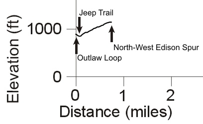
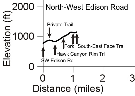
North-West Edison Road T1
![]()
Description This Edison Road cimbs from the South-West Edison Road (about 220 yards from the Western Plateau Trail) to the ridge that separates the Western Plateau from the Santa Rosa Valley. A short spur that leads to the highest point of this ridge connects to the Lichen Trail.
This main road continues over the top of the ridge and down the other side into the Santa Rosa Valley. The map shows only the first leg of the route down.
Technical Rating T1
![]()
|
Length (miles) |
1.15 (to the little building at the top) |
|
Climb (feet) |
450 |
|
Descent (feet) |
80 |
Trail Profile Back to the Top
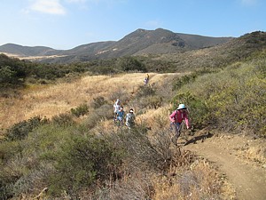
Outlaw Loop T2.5
![]()
 Description It's
a bit of a mystery as to who built this trail, hence the name. It climbs up the south
flank of Elliott Mountain from the north leg of the Western Plateau Trail. There
are many twists and turns, especially along the original west half, providing
great views of the plateau below and points south. You'll get a good workout
climbing up here, and mountain bikers will have to be good at handling tight
turns if they're going to enjoy it!
Description It's
a bit of a mystery as to who built this trail, hence the name. It climbs up the south
flank of Elliott Mountain from the north leg of the Western Plateau Trail. There
are many twists and turns, especially along the original west half, providing
great views of the plateau below and points south. You'll get a good workout
climbing up here, and mountain bikers will have to be good at handling tight
turns if they're going to enjoy it!
During the Annual COSCA Trailwork Day in 2013, a new route for the east half was built with most of the old route being closed off. The new route isn't as steep and goes right out to the edge of Hill Canyon, giving a great view of the canyon and Lizard Rock in Wildwood on the other side. Even so, it has some short rocky and challenging sections that many mountain bikers will want/need to walk.
Technical Rating T2.5
![]()
|
Length (miles) |
1.6 |
|
Climb (feet) |
300 |
|
Descent (feet) |
300 |
Trail Profile Back to the Top
Peninsula Loop Trail T2
![]() ,
T2.5
,
T2.5
![]()
 Description The
Penisula Loop Trail runs along a ridge from the Western Plateau down towards Hawk
Canyon, rejoining the Western Plateau Trail
about half way down. When returning to the trailhead on Conejo Center Drive,
I prefer this trail over the Western Plateau Trail Edison road because it is
higher and has much better views, especially the section built in 2016 because
it faces north into the center of the plateau and towards Elliott Mountain.
Description The
Penisula Loop Trail runs along a ridge from the Western Plateau down towards Hawk
Canyon, rejoining the Western Plateau Trail
about half way down. When returning to the trailhead on Conejo Center Drive,
I prefer this trail over the Western Plateau Trail Edison road because it is
higher and has much better views, especially the section built in 2016 because
it faces north into the center of the plateau and towards Elliott Mountain.
In October 2016 during the Conejo Open Space Trailwork Day, a bypass of a very steep section was built at the bottom of the trail where it joins the Western Plateau Trail. The old section of 300' that descends 50' is replace by 1600' of new trail and so is much less steep.
Technical Rating T2
![]() ,
T2.5
,
T2.5
![]() at the bottom
at the bottom
|
Length (miles) |
0.62 |
|
Climb (feet) |
50 (West to east) |
|
Descent (feet) |
175 |
 Trail Profile Back to
the Top
Trail Profile Back to
the Top
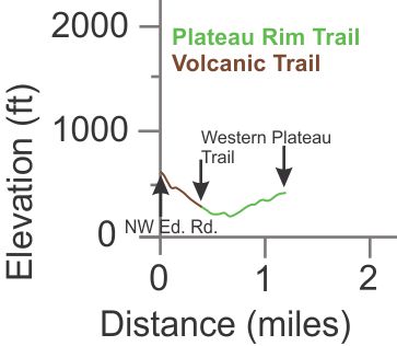
 Plateau Rim Trail (Previously
Hawk Canyon Rim Trail) T2
Plateau Rim Trail (Previously
Hawk Canyon Rim Trail) T2
Description This singletrack trail runs in a horseshoe shape, meandering through the grasslands of the plateau and passing the overlook bench of Hawk Canyon. It starts and ends at the Western Plateau Trail. It's a great hiking trail, and possibly the most fun trail for mountain biking in Thousand Oaks! On the north end, Volcanic comes out directly across from it, so a common route for mountain bikers is down Volcanic, along Plateau Rim and then down Peninsula Loop.
Technical Rating T2
![]()
|
Length (miles) |
0.8 miles |
|
Climb (feet) |
150 (North-east to south-west) |
|
Descent (feet) |
90 |
Trail Profile Back to the Top
Description This trail is on private property and leads to an equestrian facility. They are not happy to see members of the public on their trail. If you don't believe it, they will make it clear to you if you encouter them along the way.
South-West Edison Road T1
![]()
Description This Edison Road climbs to the south-west from the Western Plateau Trail to a point that overlooks the 101 Freeway.
Technical Rating T1
![]()
|
Length (miles) |
0.95 |
|
Climb (feet) |
300 |
|
Descent (feet) |
200 |
Unnamed (AKA
Powerline Connect)
T2.5
![]()
Description This mostly singletrack trail climbs from the Western Plateau Trail up to the North-West Edison Road. We use it to access Volcanic. Because of some nasty ruts, it rates T2.5 instead of T2.
Technical Rating
T2.5
![]()
|
Length (miles) |
0.3 |
|
Climb (feet) |
115 (From the Western Plateau Trail to the NW Edison Road) |
|
Descent (feet) |
Zero |
Up and Away (AKA Edison Connector) T2
![]()
Description This road/trail connects the Western Plateau Trail just west of the Plateau Rim Trail to the North-West Edison Road. The top half is an Edison spur that leads to a power tower. The lower half is a double-track.
Technical Rating T2
![]()
|
Length (miles) |
0.56 |
|
Climb (feet) |
290 (Going up/north-west from the Western Plateau Trail) |
|
Descent (feet) |
zero |
Trail Profile Back to the Top
 Volcanic Trail T3
![]()
Description This singletrack trail runs mostly downhill from the unnamed Edison connector trail near the top to the Western Plateau Trail, directly across from the Plateau Rim Trail. There is one brief rise. The trail is littered with small loose volcanic rocks about the size of walnuts, and has cactus along the sides in places. For experienced mountain bikers, it's a really fun downhill, but use caution on the slippery rocks next to the cacti!
Technical Rating T3
![]()
|
Length (miles) |
0.4 |
|
Climb (feet) |
10 |
|
Descent (feet) |
170 |
Trail Profile Back to the Top
Western Plateau Trail T1.5
![]()
 Description This hilly,
U-shaped Edison Road is the primary way to get to the trails of this area. It
connects to the two major trailheads; on Conejo Center Drive (south-east end
in Newbury Park) and, via Hill Canyon Fireroad,
on Hill Canyon Road in the Santa Rosa Valley. The trail will give hikers and
bikers a good workout with its hills, but it's probably too steep for beginner
mountain bikers.
Description This hilly,
U-shaped Edison Road is the primary way to get to the trails of this area. It
connects to the two major trailheads; on Conejo Center Drive (south-east end
in Newbury Park) and, via Hill Canyon Fireroad,
on Hill Canyon Road in the Santa Rosa Valley. The trail will give hikers and
bikers a good workout with its hills, but it's probably too steep for beginner
mountain bikers.
If it has rained recently, this road turns into gooey mud that sticks to everything. Stay off when wet!
Technical Rating T1.5
![]()
|
Length (miles) |
2.75 |
|
Climb (feet) |
350 (going clockwise) |
|
Descent (feet) |
650 |
Trail Profile Back to the Top
This page was last updated February 2, 2024
|
|
Thanks for looking at Steve's guide to trails in Ventura County, the Santa Monica Mountains National Recreation Area (SMMNRA) and other locations. |
|